Jatun Ch'utu
For the mountain in the Cochabamba Department, Bolivia, see Jatun Ch'utu (Cochabamba).
| Jatun Ch'utu | |
|---|---|
 Jatun Ch'utu Location within Bolivia | |
| Highest point | |
| Elevation | 4,220 m (13,850 ft) [1] |
| Coordinates | 19°42′11″S 65°49′34″W / 19.70306°S 65.82611°WCoordinates: 19°42′11″S 65°49′34″W / 19.70306°S 65.82611°W |
| Geography | |
| Location |
Bolivia, Potosí Department |
| Parent range | Andes |
Jatun Ch'utu (Quechua jatun big, ch'utu cone,[2] "big cone", also spelled Jatun Chutu) is a mountain in the Bolivian Andes which reaches a height of approximately 4,220 m (13,850 ft). It is located in the Potosí Department, Tomás Frías Province, Potosí Municipality. It lies southeast of the village of Juch'uy Wasi (Juchuy Huasi). The Jatun Mayu flows along its southern slopes.[1][3]
References
Capital: Potosí | ||
| Provinces | 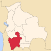 | |
| Municipalities (and seats) |
| |
This article is issued from Wikipedia - version of the 5/2/2016. The text is available under the Creative Commons Attribution/Share Alike but additional terms may apply for the media files.