International Reference Ionosphere

International Reference Ionosphere (IRI) is a common permanent scientific project of the Committee on Space Research and the International Union of Radio Science started 1968/69. It is the international standard empirical model for the terrestrial ionosphere since 1999. For a specified geographic location, time, and date, the IRI provides average monthly values for electron density, electron temperature and ion temperature, and the molecular composition of the ions in the range of altitudes from 50 km to 2000 km.[1] The latest standard is IRI-2012.[1][2]
History
Karl Rawer, first chairman of the URSI/COSPAR Task group on the IRI (1968-`84) specified as goal of the IRI to establish a (monthly) average model of the terrestrial ionosphere based on reliably measured data obtained with ground- and space-based methods. Contradictions between these had to be resolved in critical discussions. After a decade filled with data collection a first set of tables was given out in 1978. PC-codes in ALGOL and Fortran followed. 1986 the code became available on Floppy disk, later in the Web. It is yearly improved according to the results obtained at the meetings of the task group.Since 1999 the IRI is "International Standard" for the terrestrial ionosphere.
Contents
The IRI used (and yet uses as an option) an ITU-R-model that had been developed in respect to radio propagation via the ionosphere, specifying two parameters of which one is narrowly related to the peak electron density and the other to the peak altitude of the ionosphere. Both have been and are regularly determined from Ionograms at all Ionospheric sounding stations. The authors R.M.Gallet and W.B.Jones had worldwide analyzed a wealth of such data by a method combining Fourier- analysis in time with worldwide Legendre-analysis of the Fourier-coefficients. Meanwhile, regional models are often applied because they reach better local performance.
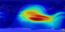
The IRI-model specifies vertical profiles of electron density, electron and ion temperature and the relative share of the different positive ions. Vertical electron content may be derived. (A snapshot is shown in the latitude vs. longitude map aside).[3]
References
- 1 2 Bilitza, D. "IRI - International Reference Ionosphere". nasa.gov. NASA. Retrieved 24 April 2015.
- ↑ "International Reference Ionosphere - IRI-2012". nasa.gov. NASA. Retrieved 24 April 2015.
- ↑ http://ccmc.gsfc.nasa.gov/modelweb/ionos/iri.html
Literature
- D.Bilitza: 35 years of International Reference Ionosphere.... Adv.in Radio Science 2,.pp. 283–287 2004
- M.Hernandez-Pajares et al.:Combining GPS measurements and IRI model values for Space weather specification. Adv .Space Research 29,pp. 949–958 2002
- K.Rawer et al.:International Reference Ionosphere 1978. International Union of Radio Science,Brussels 1978
- W.B.Jones, R.M.Gallet:Telecomm.J.29, pp. 129ff 1965