Inage-ku
| Inage 稲毛区 | |
|---|---|
| Ward | |
| Inage Ward | |
|
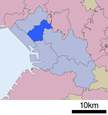
Location of Inage in Chiba | |
 Inage
| |
| Coordinates: 35°38′11″N 140°06′26″E / 35.63639°N 140.10722°ECoordinates: 35°38′11″N 140°06′26″E / 35.63639°N 140.10722°E | |
| Country | Japan |
| Region | Kantō |
| Prefecture | Chiba |
| City | Chiba |
| Area | |
| • Total | 21.25 km2 (8.20 sq mi) |
| Population (April 2012) | |
| • Total | 156,860 |
| • Density | 7,380/km2 (19,100/sq mi) |
| Time zone | Japan Standard Time (UTC+9) |
| Address |
4-12-1 Anegawa, Inage-ku Chiba-shi, Chiba-ken 263-8733 |
| Website | Official website of Inage-ku |


Inage Ward (稲毛区 Inage-ku) is one of the six wards of the city of Chiba in Chiba Prefecture, Japan. As of April 2012, the ward had an estimated population of 156,860 and a population density of 7,380 persons per km². The total area was 21.25 square kilometres (8.20 sq mi).[1][2]
Geography
Inage Ward is located in an inland area of northwest Chiba City. The ward is a flat, highly urbanized area of mixed industry and housing.
Surrounding municipalities
History
The area of present-day Inage Ward was settled since ancient times. The Inage Sengen Shrine dates to the 9th century. In modern times, Inage was composed of the villages of Tsuga, Kemigawa, Kotegawa and a portion of the town of Chiba in 1889. Kemigawa became a town in 1891, and Chiba became a city in 1921. Chiba annexed Tsuga Village and Kemigawa Town in 1937, and Kotegawa in 1954.[1] Inage historically faced Tokyo Bay, and given its proximity to Tokyo, was a popular tourist destination for swimming and clamming. Numerous beach huts were constructed along the Tokyo Bay coast.[1] The ward became landlocked by 1961 after the extensive land reclamation projects were completed along the coast of Tokyo Bay in Chiba Prefecture.[3] As part of the development of Chiba City, numerous planned residential districts were built in Inage after World War II due to the development of the JR East Sōbu and Keisei Chiba lines. The construction of planned housing complexes continues in the ward.[4] With the promotion of Chiba to a designated city, the city gained additional autonomy from Chiba Prefecture and the central government. Accordingly, on April 1, 1992 Inage Ward was established as an administrative unit.[1][3]
Economy
Inage Ward is largely a regional commercial center and bedroom community for central Chiba and Tokyo. In the northern part of the ward is Nairiku Industrial Park (内陸工業団地 Nairiku kōgyōdanchi).
Transportation
Rail
- JR East – Sōbu Line
- JR East – Chiba Line
- Chiba Urban Monorail – Line 2
Highways
- Higashi-Kantō Expressway
- Keiyō Road
- Japan National Route 14
- Japan National Route 16
- Japan National Route 126
Education
Inage-ku is home to the main campus of Chiba University. Additionally, Keiai University and Chiba Keizai University are located in the ward.[3]
Festival
The festival of the Inage Sengen Shrine is held annually on July 15. Its kagura, a type of Shinto theatrical dance, is designated a Chiba Prefectural Intangible Treasure.[1]
Noted people from Inage Ward
- Ryo Kawashima, professional baseball player
- Satoru Yamagishi – professional soccer player
- Koki Yonekura – professional soccer player
- Yasushi Kanda – professional wrestler
| Wikimedia Commons has media related to Inage-ku, Chiba. |
References
- 1 2 3 4 5 6 "稲毛" [Inage]. Nihon Daihyakka Zensho (Nipponika) (in Japanese). Tokyo: Shogakukan. 2012. OCLC 153301537. Retrieved 2012-07-03.
- ↑ "稲毛" [Inage]. Nihon Rekishi Chimei Taikei (in Japanese). Tokyo: Shogakukan. 2012. OCLC 173191044. dlc 2009238904. Retrieved 2012-07-01.
- 1 2 3 "稲毛" [Inage]. Nihon Kokugo Daijiten (in Japanese). Tokyo: Shogakukan. 2012. OCLC 56431036. Retrieved 2012-08-03.
- ↑ "稲毛" [Inage]. Dijitaru daijisen (in Japanese). Tokyo: Shogakukan. 2012. OCLC 56431036. Retrieved 2012-07-03.