Hopton Castle, Shropshire
| Hopton Castle | |
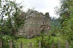 The Keep, Hopton Castle |
|
 Hopton Castle |
|
| OS grid reference | SO363782 |
|---|---|
| Civil parish | Hopton Castle |
| Unitary authority | Shropshire |
| Ceremonial county | Shropshire |
| Region | West Midlands |
| Country | England |
| Sovereign state | United Kingdom |
| Post town | CRAVEN ARMS |
| Postcode district | SY7 |
| Dialling code | 01547 |
| Police | West Mercia |
| Fire | Shropshire |
| Ambulance | West Midlands |
| EU Parliament | West Midlands |
| UK Parliament | Ludlow |
|
|
Coordinates: 52°23′53″N 2°56′10″W / 52.398°N 2.936°W
Hopton Castle is a small village and civil parish in south Shropshire, England.
The village grew up near to the keep of Hopton Castle, which was opened as a visitor attraction in 2011. Nearby is the hamlet of Hopton Heath, with its railway station on the Heart of Wales Line. Also nearby are the villages of Bedstone, Bucknell and Clungunford.
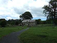
St Edward's church at Hopton Castle
Instead of a parish council it has a parish meeting;[1] this is due to the very small population of the parish.
Hopton Titterhill
Within the parish, to the southwest of the village, lies Hopton Titterhill, a wooded hill which is open access land. The hill rises to 397 metres (1,302 ft) above sea level, and the summit provides a good view of the lower Clun valley.
References
- ↑ Shropshire Council Map of Local Joint Committee 19
This article is issued from Wikipedia - version of the 9/1/2016. The text is available under the Creative Commons Attribution/Share Alike but additional terms may apply for the media files.