Haisborough Sands
| Haisborough Sands | |
| Haisboro Sands or Haisbro Sands | |
| Coastal feature | |
 Location map of Haisborough Sands | |
| Official name: Haisborough Sands | |
| Country | United Kingdom |
|---|---|
| District | Coastal East of England |
| Municipality | Norfolk |
| Location | Southern North Sea |
| Length | 16 km (10 mi), North west to South east |
| Width | 1.6 km (1 mi) |
| Area | 31.249 km2 (12 sq mi) |
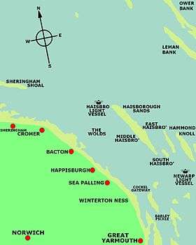
Haisborough Sands (or Haisboro Sands or Haisbro Sands) is a sandbank off the coast of Norfolk, England at Happisburgh.[1] The shoal is 10 miles (16 km) long and 1 mile (1.6 km) wide and lies parallel to the North east coast of Norfolk. The shoal is marked to the north-west by north by the Haisbro Light Buoy, North cardinal. To the south-east by south is a light buoy South cardinal, and to the west by Mid Haisbro light buoy starboard hand. In 1995 there were three drying patches recorded to the north-north east and east-south east of the Mid Haisbro light buoy. Except at slack water their positions are indicated by tidal eddies and in slight or moderate seas the swell breaks on the shallower parts of the banks. There are a number of foul patches on the southern part of the shoal. There are very strong eddies on and around the bank especially on the north west. Over the years this shoal has claimed many ships.[2]
Description
The main ridge of the shoal is made up of five distinct areas.[3] These are named Haisborough Sand, Haisborough Tail, Hammond Knoll, Winterton Ridge and Hearty Knoll.[3] To the eastern edge of the sands there are areas called Hewett Ridge and Smiths Knoll which form a ridge of sandbanks on the outer boundary of the sands.[3] Inshore and to the west there are additional banks including Winterton Shoal and the Newarp Banks.[3]
Fish and mammals
Haisborough Sands and its surrounding shoals are known to be spawning grounds[3] for Sand eels Ammodytes, Lemon sole Microstormus Kitt and sole Solea solea. The sands also provide nursery grounds for Cod Gadus morhua, Herring Clupea harengus, Mackerel Scomber scombrus, Sole, Lemon sole and Plaice Pleuronectes platessa.[3] There are small numbers of Harbour porpoise regularly observed within the boundaries of the sands. The common seals Phoca vitulina which are resident in the Wash are occasionally observed in this area.[4]
Ships wrecked on Haisborough Sands
Some of the ships wrecked here include:
- HMS Invincible - 16 March 1801
- SS Chicago - 1878[5]
- Barque Brownrigg on the 12 August 1888
- SS Cambria after a collision with SS Killingworth on the 14 May 1891
- Barque Ceylon of Christiania, Norway, 1893
- Optima ex Placilla - 18 January 1905[6]
- SS Atbara of London on the 11 February 1907
- Steamer - 1907[7]
- Barque Alf of Laurvig, Norway on the 23 November 1909[2]
- SS Bodil of Esbjerg on the 26 May 1915
- SS Camille on the 6 January 1916
- SS Kronprindsesse Victoria of Haugesund, Norway. 26. November 1917
- SS Georgia - 1927[2]
- SS Monte Nevoso during the 14 to 16 October 1932[8]
- SS Meriones[2] 26 January 1941[8]
- SS Gallois[2] part of Convoy FS 559 on the 6 August 1941
- SS Oxshott[2] of London part of Convoy FS 559 on the 6 August 1941
- SS Aberhill[2] of Methil, Fife part of Convoy FS 559 on the 6 August 1941
- SS Taara[2] of Pärnu, Estonia part of Convoy FS 559 on the 6 August 1941
- SS Paddy Hendly[2] on her maiden voyage part of Convoy FS 559 on the 6 August 1941
- SS Deerwood[2] of London part of Convoy FS 559 on the 6 August 1941
- SS Betty Hindley[2] part of Convoy FS 559 on the 6 August 1941
- SS Afon Towy on the 6 August 1941
- HM Trawler Agate (referred to as T87 by the Admiralty[2]) part of Convoy FS 559 on the 6 August 1941
- Trawler MV Cuttlefish - 1981[9]
- City of Sunderland - 2008[10]
Gallery
- The SS Monte Nevoso marooned on the Haisborough Sands
- Admiralty chart of Haisborough Sands
_p125_-_Plate_VI._Haishorough%2C_general_plan.jpg) Chart of the Haisborough Sands Lighthouse
Chart of the Haisborough Sands Lighthouse
See also
- Happisburgh Lifeboat Station
- Hammond's Knoll - nearby sandbank, similarly treacherous
- Scroby Sands
References
- ↑ SC1408 Harwich and Rotterdam to Cromer & Terschelling Admrialty Small Craft Chart Coastal planning chart of the Harwich and Rotterdam to Cromer and Terschelling Scale: 1:300,000
- 1 2 3 4 5 6 7 8 9 10 11 12 The Ship-Wrecks off North East Norfolk by Ayer Tikus: Published by Ayer Tikus Publications; ASIN B0032Z2NU0
- 1 2 3 4 5 6 Special Area of Conservation (SAC):Haisborough, Hammond and Winterton
- ↑ Scira Offshore Energy Ltd., 2006; Centrica, 2007
- ↑ "The Ships List: Furness Line". Retrieved 2008-08-06.
- ↑ "Placilla (1892)". Retrieved 2008-12-31.
- ↑ "Nuggets of information". RNLI. Retrieved 2008-08-06.
- 1 2 "Henry Blogg, the Greatest of the Lifeboatmen", Jolly, C., Pub: Poppyland Publishing, new edition 2002, ISBN 0-946148-59-7
- ↑ "Fleetwood Online Archive of Trawlers". Retrieved 2008-08-06.
- ↑ "Maritime Accident Casebook". Retrieved 2008-08-06.
Coordinates: 52°54′N 1°42′E / 52.900°N 1.700°E