Grade I listed buildings in Coventry

There are 19 Grade I listed buildings in the City of Coventry. In the United Kingdom, a listed building is a building or structure of special historical or architectural importance. These buildings are legally protected from demolition, as well as from any extensions or alterations that would adversely affect the building's character or destroy historic features. Listed buildings in England and Wales are divided into three categories—Grade II buildings are buildings of special interest; Grade II* buildings are Grade II buildings of particular interest; and Grade I buildings, which are those of "exceptional" interest. Only around four per cent of listed buildings are given Grade I status.[1]
Coventry is an ancient city and a metropolitan borough in the West Midlands of England. The city's history dates back to at least the 11th century (CE), and by the 14th century, it was a thriving centre of commerce. Like many of Coventry's Grade I listed buildings, the city's walls were erected towards the end of the end of the 14th and the beginning of the 15th centuries. Of the 20 buildings on this list, 14 are in the city centre, and 11 date back to the 14th century. The oldest is St. Mary's Priory, now a ruin, which was founded in 1043. Several other buildings in this list date from the 12th century. The youngest Grade I listed building in the city is the new cathedral, built in the 1950s to replace the 14th-century original. Like much of the city centre, the original cathedral was almost completely destroyed in the Coventry Blitz in November 1940, and the new cathedral was built next to the ruin, which was preserved.[2]
A 20th building, Coombe Abbey, in Coombe Country Park (SP 40351 79757) is owned by Coventry City Council but falls just outside the city boundary and into the Borough of Rugby in Warwickshire and thus is not included in this list.[1][3]
List of buildings
| Name | Location | Type | Completed [note 1] | Date designated | Grid ref.[note 2] Geo-coordinates | Notes | Entry number [note 3] | Image |
|---|---|---|---|---|---|---|---|---|
| 38–39 Bayley Lane, medieval basement | Bayley Lane, City Centre | Building | 14th century | 5 February 1955 | SP3366178962 52°24′27″N 1°30′24″W / 52.407634°N 1.506608°W |
Numbers 38 and 39 no longer exist, but the mediaeval stone undercroft on the site remains. Accessible from the Herbert Art Gallery and Museum.[1][4] | 1116387 | |
| St Mary's Hall | Bayley Lane, City Centre | Guildhall | 14th century | 5 February 1955 | SP3357678957 52°24′27″N 1°30′28″W / 52.407594°N 1.507858°W |
Mediaeval guildhall that has functioned as a meeting place for various groups since the 14th century. Once the prison of Mary, Queen of Scots.[1][5][6][lower-alpha 1] | 1116402 |  |
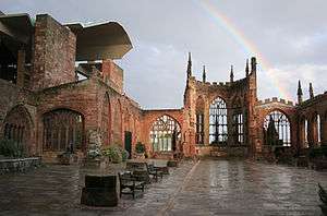
| Ruined cathedral | Bayley Lane/St Michael's Avenue, City Centre | Cathedral | 14th century | 5 February 1955 | SP3360278975 52°24′28″N 1°30′27″W / 52.407755°N 1.507474°W |
A 14th-century church and later cathedral. Now a ruin, having been destroyed on 14 November 1940 during the Coventry Blitz.[1][7] | 1076651 | |
| All Saints Church, Allesley | Birmingham Road, Allesley | Church | 13th century | 5 February 1955 | SP3019080655 52°25′23″N 1°33′27″W / 52.423056°N 1.557478°W |
Allesley's village church. Originally built in the years following the Norman conquest, but the current building is 13th-century in origin, though it underwent significant rebuilding in the mid 19th century. The church's wall monuments are of particular interest.[1][8] | 1342900 |  |
| Church of St Bartholomew | Brinklow Road, Binley | Church | 1770s | 5 February 1955 | SP3772978494 52°24′11″N 1°26′49″W / 52.403162°N 1.446864°W |
An 18th-century church, now serving the area of Binley, but originally built to serve Coombe Abbey.[1][9] | 1076629 | |
| Cook Street Gate | Cook Street, City Centre | Town gate | 14th century | 5 February 1955 | SP3353479449 52°24′43″N 1°30′30″W / 52.41202°N 1.508426°W |
One of two remaining gates in the city walls (and the only one still capable of serving as a gate), which were built in the 14th and early 15th centuries despite city walls having little defensive function by then. Cook Street Gate is a crenellated tower above an arch approximately 150 metres (490 ft) from Swanswell Gate (below).[1][10][lower-alpha 2] | 1076640 |  |
| Caludon Castle (remains) | Farren Road, Wykenc | Castle | Late 12th century | 5 February 1955 | SP3737980159 52°25′05″N 1°27′07″W / 52.418154°N 1.451822°W |
All that remains of Caludon Castle is a large grey sandstone wall, but the site was occupied from at least the 11th century until 1815. The site was occupied by several buildings, including a manor, a castle (for which it is named), and a large house, and the surviving wall fragment now sits in an urban park to the east of Coventry city centre.[1][11][lower-alpha 2] | 1076645 | |
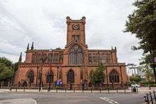
| Church of St John the Baptist | Fleet Street/Corporation Street, City Centre | Church | 1343 | 5 February 1955 | SP3305979081 52°24′31″N 1°30′56″W / 52.40874°N 1.515445°W |
A large church at the foot of the historic Spon Street, founded in 1343 and restored in 1608 and 1875–77. Royalist prisoners may have been held here during the English Civil War, which in turn may be the origin of the phrase "sent to Coventry".[1][12][13] | 1342889 |  |
| Ford's Hospital | Greyfriar's Lane, City Centre | Hospital | 16th century | 5 February 1955 | SP3339978822 52°24′23″N 1°30′38″W / 52.406392°N 1.510473°W |
A timber-framed almshouse built around a courtyard, providing housing for six elderly people. Founded in 1509, it was badly damaged during the Coventry Blitz, but restored in the 1950s.[1][14] | 1342891 | |
| Whitefriars | Gulson Road, City Centre | Friary | Circa 1342 | 5 February 1955 | SP3400378659 52°24′18″N 1°30′06″W / 52.404889°N 1.501611°W |
The remains of a 14th-century Carmelite friary that was abandoned in the Dissolution of the Monasteries. The buildings were used for a variety of purposes from the 16th century onwards and is now used by the nearby Herbert Art Gallery and Museum. All that remains is the cloister wing, located just outside the Coventry ring road, and the gateway from Much Park Street, just inside the ring road.[1][15] | 1076648 |  |
| The Old Grammar School (St John's Hospital) | Hales Street, City Centre | Grammar School | 12th century | 5 February 1955 | SP3338179297 52°24′38″N 1°30′38″W / 52.410663°N 1.51069°W |
Hospital and chapel dating from the 12th century. Sold and converted to a school in the 16th century, which moved to a larger site in 1885.[1][16] | 1320431 |  |
| Swanswell Gate and city wall to the north | Hales Street | Gate House | Circa 1395 | 5 February 1955 | SP3356279360 52°24′40″N 1°30′29″W / 52.411218°N 1.508023°W |
One of two remaining gates in the city walls, which were built in the 14th and early 15th centuries despite city walls having little defensive function by then. The gatehouse, which is now a private residence, is all that survives. The gatehouse is rectangular, constructed from sandstone, and has a crenelated roof. Contiguous to the gatehouse are Lady Herbert's Garden and the largest remaining fragment of the city walls.[1][17] | 1076649 | |
| 22 High Street (cellar) | High Street, City Centre | Building | 15th century | 5 February 1955 | SP3348878920 52°24′26″N 1°30′33″W / 52.407267°N 1.509155°W |
Mediaeval sandstone crypt underneath High Street. Only the cellar is listed—the modern building above it is not. The cellar and that of 21 High Street (itself grade II listed) were originally one, but are divided by modern brickwork.[1][18] | 1076612 | 
|
| Bablake School (former site) | Hill Street, City Centre | School | 14th century | 5 February 1955 | SP3304279119 52°24′33″N 1°30′56″W / 52.409083°N 1.515691°W |
Built in the 14th century as priests' quarters for the nearby St John's church (above). Rebuilt in 1560 as a boys' school. The building has an ashlar wall facing the road on the ground floor and an oversailing timber-framed first floor.[1][19] | 1076616 | |
| The Charterhouse | London Road | Timber Framed House | 1381 | 5 February 1955 | SP3447678218 52°24′03″N 1°29′41″W / 52.400895°N 1.494704°W |
The original building on the site was the Charterhouse of St Anne, founded in 1381. The current building is the result of many later additions, including timber-framing on the north side. The doors and many of the windows date from the 18th century. Also included in the listing are a collection of 15th- and 16th-century paintings.[1][20] | 1076621 | |
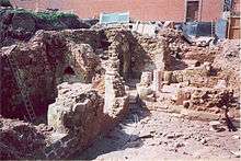
| St. Mary's Priory (ruins) | Priory Row, City Centre | Priory | 1043 | 5 February 1955 | SP3349079109 52°24′32″N 1°30′33″W / 52.408966°N 1.509107°W |
11th-century priory built by Lady Godiva and Leofric, Earl of Mercia. The exposed foundations are the only surviving architecture, and a garden has been built around them. The priory was rediscovered in the 19th century when the Blue Coat School was first built. The site has been excavated several times throughout the 20th and 21st century. The school moved in the 1960s and the school building on the priory site is now a grade II* listed building in its own right.[1][21][lower-alpha 2] | 1076588 |  |
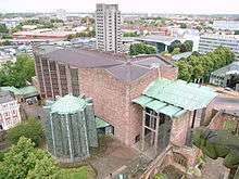
| Coventry Cathedral (new building) | Priory Street, City Centre | Cathedral | 1951-62 | 29 March 1988 | SP3362779065 52°24′31″N 1°30′26″W / 52.408562°N 1.507097°W |
The 20th-century replacement for the 14th-century cathedral which was destroyed in the Second World War. One of the United Kingdom's most significant architectural commissions in the second half of the 20th century, the cathedral was designed by Sir Basil Spence after a competition. The new cathedral was built between 1951 and 1962 from red sandstone, with concrete and green slate. It is the newest building on this list.[1][22] | 1342941 |  |
| Holy Trinity Church | Trinity Lane, City Centre | Church | 13th century | 5 February 1955 | SP3351179052 52°24′30″N 1°30′32″W / 52.408452°N 1.508804°W |
Mediaeval church with later alterations. The spire was rebuilt in the middle of the 17th century and the rest of the church restored in the mid 19th century. Two stained-glass windows were added in the 1950s.[1][23] | 1342893 |  |
| St Mary Magdalene's Church | Wyken Croft, Wyken | Church | 12th century | 5 February 1955 | SP3666980765 52°25′25″N 1°27′44″W / 52.42365°N 1.462195°W |
Originally built in the 12th century, but with later rebuilding and restoration, only the chancel and the original doorway survive. The tower was added in the 15th century. Much of the rest of the building, including the spire (which was added to the tower) dates to the 19th century. The nave contains a 15th-century wall painting depicting Saint Christopher.[1][24] | 1076583 |  |
See also
| Wikimedia Commons has media related to Grade I listed buildings in Coventry. |
Notes
- ↑ St Mary's Hall was formerly a Scheduled Ancient Monument.
- 1 2 3 Cook Street Gate, Swanswell Gate, the ruins of St Mary's Priory, and the remains of Caludon Castle are also Scheduled Ancient Monuments and subject to other legislation, which takes precedence over listed building procedures.[1]
- ↑ The date given is the date used by Historic England as significant for the initial building or that of an important part in the structure's description.
- ↑ Sometimes known as OSGB36, the grid reference is based on the British national grid reference system used by the Ordnance Survey.
- ↑ The "List Entry Number" is a unique number assigned to each listed building and scheduled monument by Historic England.
References
- 1 2 3 4 5 6 7 8 9 10 11 12 13 14 15 16 17 18 19 20 21 22 "Statutory List of Buildings of Special Architectural or Historic Interest". Coventry City Council. Retrieved 24 August 2012.
- ↑ Soden, Ian (2005). Coventry: The Hidden History. Tempus Publishing Ltd. pp. 7–8. ISBN 9780752433455.
- ↑ "Combe Abbey and Bridge Over Moat Attached to South". The National Heritage List for England. English Heritage. Retrieved 24 August 2012.
- ↑ "Medieval basement below numbers 38 and 39". The National Heritage List for England. English Heritage. Retrieved 24 August 2012.
- ↑ "St Mary's Hall". The National Heritage List for England. English Heritage. Retrieved 24 August 2012.
- ↑ "Step inside Coventry's Guildhall". BBC Coventry and Warwickshire. BBC. 19 October 2009. Retrieved 16 October 2012.
- ↑ "Ruined Cathedral Church of St Michael". The National Heritage List for England. English Heritage. Retrieved 24 August 2012.
- ↑ "Church of All Saints". The National Heritage List for England. English Heritage. Retrieved 24 August 2012.
- ↑ "Church of St Bartholomew". The National Heritage List for England. English Heritage. Retrieved 24 August 2012.
- ↑ "City Gate". The National Heritage List for England. English Heritage. Retrieved 24 August 2012.
- ↑ "Remain of Caludon Castle". The National Heritage List for England. English Heritage. Retrieved 24 August 2012.
- ↑ "Church of St John the Baptist". The National Heritage List for England. English Heritage. Retrieved 24 August 2012.
- ↑ "A Colourful History...". sponstreetcoventry.co.uk. Spon Street Coventry. Retrieved 26 June 2012.
- ↑ "Ford's Hospital". The National Heritage List for England. English Heritage. Retrieved 24 August 2012.
- ↑ "Whitefriars Museum". The National Heritage List for England. English Heritage. Retrieved 24 August 2012.
- ↑ "The Old Grammar School (St John's Hospital)". The National Heritage List for England. English Heritage. Retrieved 24 August 2012.
- ↑ "City Wall to the north of Swanswell Gate". The National Heritage List for England. English Heritage. Retrieved 24 August 2012.
- ↑ "Number 22 (Cellerage Only)". The National Heritage List for England. English Heritage. Retrieved 24 August 2012.
- ↑ "Bablake School". The National Heritage List for England. English Heritage. Retrieved 24 August 2012.
- ↑ "The Charterhouse, Coventry". The National Heritage List for England. English Heritage. Retrieved 24 August 2012.
- ↑ "Priory ruins". The National Heritage List for England. English Heritage. Retrieved 24 August 2012.
- ↑ "Cathedral of St Michael". The National Heritage List for England. English Heritage. Retrieved 24 August 2012.
- ↑ "Holy Trinity Church". The National Heritage List for England. English Heritage. Retrieved 24 August 2012.
- ↑ "Church of St Mary Magdalene". The National Heritage List for England. English Heritage. Retrieved 24 August 2012.