Gorca
| Gorca | |
|---|---|
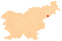
 Gorca Location in Slovenia | |
| Coordinates: 46°20′6.41″N 15°51′49.69″E / 46.3351139°N 15.8638028°ECoordinates: 46°20′6.41″N 15°51′49.69″E / 46.3351139°N 15.8638028°E | |
| Country |
|
| Traditional region | Styria |
| Statistical region | Drava |
| Municipality | Podlehnik |
| Area | |
| • Total | 6.11 km2 (2.36 sq mi) |
| Elevation | 286.9 m (941.3 ft) |
| Population (2002) | |
| • Total | 148 |
| [1] | |
Gorca (pronounced [ˈɡoːɾtsa]) is a settlement in the Haloze Hills above the left bank of the Dravinja River in the Municipality of Podlehnik in eastern Slovenia. The area traditionally belonged to the Styria region. It is now included in the Drava Statistical Region.[2]
The parish church in the settlement is dedicated to the Holy Trinity and belongs to the Roman Catholic Archdiocese of Maribor. The parish is known as Sveta Trojica–Podlehnik. The church was built in 1654.[3]
References
External links
| Settlements | Administrative centre: Podlehnik
|  |
|---|---|---|
| Landmarks |
| |
This article is issued from Wikipedia - version of the 6/23/2016. The text is available under the Creative Commons Attribution/Share Alike but additional terms may apply for the media files.