Express Island
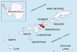
 Location of Greenwich Island in the South Shetland Islands. | |
 Express Island Location in Antarctica | |
| Geography | |
|---|---|
| Location | Antarctica |
| Coordinates | Earth 62°26′35″S 59°59′23″W / 62.44306°S 59.98972°WCoordinates: Earth 62°26′35″S 59°59′23″W / 62.44306°S 59.98972°W |
| Archipelago | South Shetland Islands |
| Area | 29 ha (72 acres) |
| Length | 1 km (0.6 mi) |
| Administration | |
|
None | |
| Demographics | |
| Population | Uninhabited |
| Additional information | |
| Administered under the Antarctic Treaty System | |

Express Island is a narrow craggy island, 1.23 kilometres (0.76 mi) long, lying close offshore of northwest Greenwich Island in the South Shetland Islands, Antarctica. It is situated due north of Greaves Peak, forming most of the east side of Razlog Cove. Surface area 29 hectares (72 acres).[1]
It was named by the UK Antarctic Place-Names Committee in 1977 after the American schooner Express (Capt. Ephraim Williams), one of the ships in the sealing fleet of Edmund Fanning and Benjamin Pendleton from Stonington, Connecticut, which operated in this area, 1820–21.[2]
See also
- Composite Gazetteer of Antarctica
- Greenwich Island (South Shetland Islands)
- List of Antarctic islands south of 60° S
- Scientific Committee on Antarctic Research
- Territorial claims in Antarctica
Map
- L.L. Ivanov et al. Antarctica: Livingston Island and Greenwich Island, South Shetland Islands. Scale 1:100000 topographic map. Sofia: Antarctic Place-names Commission of Bulgaria, 2005.
References
- ↑ L.L. Ivanov. Antarctica: Livingston Island and Greenwich, Robert, Snow and Smith Islands. Scale 1:120000 topographic map. Troyan: Manfred Wörner Foundation, 2010. ISBN 978-954-92032-9-5 (First edition 2009. ISBN 978-954-92032-6-4)
- ↑ "Express Island". Geographic Names Information System. United States Geological Survey. Retrieved 2012-03-12.
External links
![]() This article incorporates public domain material from the United States Geological Survey document "Express Island" (content from the Geographic Names Information System).
This article incorporates public domain material from the United States Geological Survey document "Express Island" (content from the Geographic Names Information System).