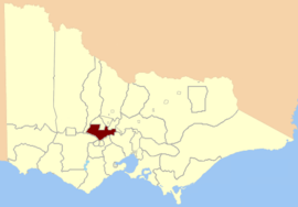
Electoral district of Creswick
| Creswick Victoria—Legislative Assembly | |
|---|---|
 Location in Victoria | |
| State | Victoria |
| Created | 1859 |
| Abolished | 1904 |
| Demographic | Rural |
Creswick was an electoral district of the Legislative Assembly in the colony, and later Australian state of Victoria centred on the town of Creswick from 1859 to 1904.[1]
It was defined in the 1858 Electoral Act, its area being bound by Greens Gully, Loddon River, Great Dividing Range, Coliban River, Middleton Creek and Limestone Creek.[2]
Members for Creswick
Two members initially, three members from 1877,[3] then one from 1889[4] in the electoral redistribution where 41 new seats were created.[5]
| Member 1 | Term | Member 2 | Term | ||
|---|---|---|---|---|---|
| William Frazer | Oct. 1859 – Dec. 1870 | John Smith | Oct. 1859 – July 1861 | ||
| Robert MacDonald | Aug. 1861 – Aug. 1864 | ||||
| James Wheeler | Nov. 1864 – Dec. 1867 | ||||
| William Miller | Mar. 1868 – Jan. 1871 | ||||
| James Stewart | Jan. 1871 – Apr. 1877 | Thomas Phillips[6] | Apr. 1871 – Mar. 1874 | Member 3 | Term |
| Richard Richardson | May 1874 – Feb. 1886 | Henry Sainsbury | May 1877 – Feb. 1880 | ||
| Thomas Cooper | May 1877 – Apr. 1889 | William Anderson | Mar. 1886 – Mar. 1889 | James Wheeler | May 1880 – Mar. 1889 |
| Richard Richardson | Apr. 1889 – Sep. 1894 | ||||
| Walter Grose | Oct. 1894 – May 1904 | ||||
- Wheeler went on to represent Daylesford April 1889 to October 1900.
- Anderson went on to represent Windermere May 1894 to May 1898.
References
- ↑ "Re-Member (Former Members)". State Government of Victoria. Retrieved 24 April 2013.
- ↑ "An Act to alter the Electoral Districts of Victoria and to increase the number of Members of the Legislative Assembly thereof." (PDF). 1858. Retrieved 24 July 2013.
- ↑ "The New Victorian Legislative Assembly". South Australian Register. Trove. 19 May 1877. Retrieved 24 April 2013.
- ↑ "The New Victorian Legislative Assembly". Western Mail. Trove. 20 April 1889. Retrieved 24 April 2013.
- ↑ "The Electoral Act Amendment Act 1888" (pdf). Retrieved 12 June 2013.
- ↑ "Parliament". The Argus. Trove. 26 April 1871. Retrieved 25 April 2013.
Coordinates: 37°26′S 143°54′E / 37.433°S 143.900°E
This article is issued from Wikipedia - version of the 6/7/2016. The text is available under the Creative Commons Attribution/Share Alike but additional terms may apply for the media files.