Ebelyakh Bay
| Ebelyakh Bay Эбеляхская губа | |
|---|---|
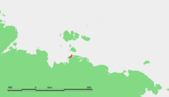
 Map showing the location of Ebelyakh Bay | |
 | |
| Location | Far North |
| Coordinates | 72°40′00″N 140°26′00″E / 72.6667°N 140.4333°ECoordinates: 72°40′00″N 140°26′00″E / 72.6667°N 140.4333°E |
| River sources | Suruktakh, Uryung-Khastakh, Adargaydakh and Ekekey |
| Ocean/sea sources | Laptev Sea |
| Basin countries | Russia |
| Max. width | 36 kilometres (22 mi) |
The Ebelyakh Bay or Ebelyakhskaya Bay (Russian: Эбеляхская губа; Ebelyakhskaya Guba) is a bay in the Laptev Sea. It is located east of the Yana Bay region and southwest of the Laptev Strait.[1]
Geography
The bay is 36 km in width and wide open to the northwest. It is limited in the north by Cape Svyatoy Nos, a prominent headland.[2]
This bay is in a vast region of wetlands. Lake Bustakh, the largest lake in the neighboring area, lies 37 km inland from the shores of the bay. Owing to is northerly location the Ebelyakh Bay is covered with ice most of the year.
The Ebelyakh Bay and the area surrounding it belong to the Sakha Republic (Yakutia) administrative division of the Russian Federation.
References
- ↑ GoogleEarth - Location
- ↑ "Mys Svyatoy Nos". Mapcarta. Retrieved 26 November 2016.
External links
This article is issued from Wikipedia - version of the 11/27/2016. The text is available under the Creative Commons Attribution/Share Alike but additional terms may apply for the media files.