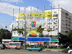
Eastern Administrative Okrug
For other entities called "Eastern District" or "Vostochny District", see Vostochny District.
| Eastern Administrative Okrug Восточный административный округ | |||
|---|---|---|---|
| Administrative okrug | |||
|
Eastern Administrative Okrug sign on Preobrazhenskaya Square | |||
| |||
 Eastern Administrative Okrug in Moscow | |||
| Coordinates: RU 55°47′N 37°46′E / 55.783°N 37.767°ECoordinates: RU 55°47′N 37°46′E / 55.783°N 37.767°E | |||
| Country | Russia | ||
| Federal city | Moscow | ||
| Districts[1] | 16[2] | ||
| Government | |||
| • Prefect | Vsevolod Timofeyev | ||
| Area | |||
| • Total | 154.6 km2 (59.7 sq mi) | ||
| Population (2010 Census)[3] | |||
| • Total | 1,452,759 | ||
| Website | http://vao.mos.ru | ||
Eastern Administrative Okrug (Russian: Восто́чный администрати́вный о́круг, Vostochny administrativny okrug), or Vostochny Administrative Okrug, is one of the twelve high-level territorial divisions (administrative okrugs) of the federal city of Moscow, Russia.[1] As of the 2010 Census, its population was 1,452,759,[3] up from 1,394,497 recorded during the 2002 Census.[2]
Territorial divisions
The administrative okrug comprises the following sixteen districts:[2]
- Bogorodskoye
- Veshnyaki
- Vostochnoye Izmaylovo
- Vostochny
- Golyanovo
- Ivanovskoye
- Izmaylovo
- Kosino-Ukhtomsky
- Metrogorodok
- Novogireyevo
- Novokosino
- Perovo
- Preobrazhenskoye
- Severnoye Izmaylovo
- Sokolinaya gora
- Sokolniki
References
Notes
- 1 2 Law #13-47
- 1 2 3 Russian Federal State Statistics Service (May 21, 2004). "Численность населения России, субъектов Российской Федерации в составе федеральных округов, районов, городских поселений, сельских населённых пунктов – районных центров и сельских населённых пунктов с населением 3 тысячи и более человек" [Population of Russia, Its Federal Districts, Federal Subjects, Districts, Urban Localities, Rural Localities—Administrative Centers, and Rural Localities with Population of Over 3,000] (XLS). Всероссийская перепись населения 2002 года [All-Russia Population Census of 2002] (in Russian). Retrieved August 9, 2014.
- 1 2 Russian Federal State Statistics Service (2011). "Всероссийская перепись населения 2010 года. Том 1" [2010 All-Russian Population Census, vol. 1]. Всероссийская перепись населения 2010 года (2010 All-Russia Population Census) (in Russian). Federal State Statistics Service. Retrieved June 29, 2012.
Sources
- Московская городская Дума. Закон №13-47 от 5 июля 1995 г. «О территориальном делении города Москвы», в ред. Закона №38 от 26 июня 2013 г. «О внесении изменений в статью 4 Закона города Москвы от 5 июля 1995 г. №13-47 "О территориальном делении города Москвы" и Закон города Москвы от 15 октября 2003 года №59 "О наименованиях и границах внутригородских муниципальных образований в городе Москве"». Вступил в силу с момента опубликования. Опубликован: "Вестник Мэрии Москвы", №14, июль 1995. (Moscow City Duma. Law #13-47 of July 5, 1995 On the Territorial Division of the City of Moscow, as amended by the Law #38 of June 26, 2013 On Amending Article 4 of the Law of the City of Moscow of July 5, 1995 #13-47 "On the Territorial Division of the City of Moscow" and the Law of the City of Moscow of October 15, 2003 #59 "On the Names and Borders of the Internal Municipal Formations in the City of Moscow". Effective as of the moment of publication.).
This article is issued from Wikipedia - version of the 11/13/2015. The text is available under the Creative Commons Attribution/Share Alike but additional terms may apply for the media files.


