Dolores, Buenos Aires
| Dolores | ||
|---|---|---|
|
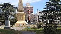
Plaza Castelli, central square of Dolores | ||
| ||
| Coordinates: 36°19′S 57°40′W / 36.317°S 57.667°WCoordinates: 36°19′S 57°40′W / 36.317°S 57.667°W | ||
| Country |
| |
| Province |
| |
| Partido | Dolores | |
| Founded | 21 August 1817 | |
| Elevation | 6 m (20 ft) | |
| Population (2001 census [INDEC]) | ||
| • Total | 24,120 | |
| CPA Base | B 7100 | |
| Area code(s) | +54 2245 | |
Dolores is a town in Buenos Aires Province, Argentina. It is the administrative centre for Dolores Partido. The town settlement was officially founded by Ramón Lara on 21 August 1817.
2008 March train disaster
On March 9, 2008 an intercity bus from the company El Rápido Argentino collided with a Ferrobaires passenger train with 250 passengers on board at a level crossing on the Provincial Highway 63 on the outskirts of Dolores, killing seventeen people and injuring at least twenty-five. The bus driver disregarded the railroad crossing signals, which at the time of the accident were operating properly.[1]
Climate
| Climate data for Dolores, Buenos Aires (1961–1990, extremes 1970–present) | |||||||||||||
|---|---|---|---|---|---|---|---|---|---|---|---|---|---|
| Month | Jan | Feb | Mar | Apr | May | Jun | Jul | Aug | Sep | Oct | Nov | Dec | Year |
| Record high °C (°F) | 40.0 (104) |
36.8 (98.2) |
38.2 (100.8) |
33.0 (91.4) |
29.7 (85.5) |
25.7 (78.3) |
30.2 (86.4) |
31.5 (88.7) |
31.7 (89.1) |
31.7 (89.1) |
34.7 (94.5) |
39.7 (103.5) |
40.0 (104) |
| Average high °C (°F) | 28.7 (83.7) |
27.7 (81.9) |
25.4 (77.7) |
21.9 (71.4) |
18.3 (64.9) |
14.4 (57.9) |
14.2 (57.6) |
15.7 (60.3) |
17.8 (64) |
20.6 (69.1) |
23.9 (75) |
27.0 (80.6) |
21.3 (70.3) |
| Daily mean °C (°F) | 21.6 (70.9) |
20.7 (69.3) |
18.5 (65.3) |
15.0 (59) |
11.6 (52.9) |
8.6 (47.5) |
8.2 (46.8) |
9.4 (48.9) |
11.6 (52.9) |
14.4 (57.9) |
17.4 (63.3) |
20.2 (68.4) |
14.8 (58.6) |
| Average low °C (°F) | 14.8 (58.6) |
14.3 (57.7) |
12.4 (54.3) |
8.9 (48) |
5.7 (42.3) |
3.6 (38.5) |
3.0 (37.4) |
3.9 (39) |
6.1 (43) |
8.8 (47.8) |
11.4 (52.5) |
13.8 (56.8) |
8.9 (48) |
| Record low °C (°F) | 3.6 (38.5) |
1.9 (35.4) |
0.8 (33.4) |
−4.2 (24.4) |
−5.6 (21.9) |
−8.0 (17.6) |
−7.2 (19) |
−6.9 (19.6) |
−5.8 (21.6) |
−2.7 (27.1) |
−2.4 (27.7) |
−0.6 (30.9) |
−8.0 (17.6) |
| Average precipitation mm (inches) | 106.7 (4.201) |
91.9 (3.618) |
89.2 (3.512) |
73.0 (2.874) |
61.6 (2.425) |
41.0 (1.614) |
60.3 (2.374) |
54.1 (2.13) |
66.0 (2.598) |
92.8 (3.654) |
86.8 (3.417) |
86.0 (3.386) |
909.4 (35.803) |
| Average precipitation days (≥ 0.1 mm) | 9 | 8 | 8 | 8 | 8 | 8 | 8 | 7 | 8 | 10 | 9 | 9 | 100 |
| Average relative humidity (%) | 73 | 76 | 79 | 80 | 81 | 83 | 83 | 80 | 78 | 78 | 76 | 73 | 78 |
| Mean monthly sunshine hours | 266.6 | 214.7 | 186.0 | 177.0 | 142.6 | 105.0 | 114.7 | 158.1 | 171.0 | 204.6 | 237.0 | 248.0 | 2,225.3 |
| Mean daily sunshine hours | 8.6 | 7.6 | 6.0 | 5.9 | 4.6 | 3.5 | 3.7 | 5.1 | 5.7 | 6.6 | 7.9 | 8.0 | 6.1 |
| Source #1: Deutscher Wetterdienst[2] | |||||||||||||
| Source #2: Oficina de Riesgo Agropecuario (record highs and lows),[3] Servicio Meteorológico Nacional (precipitation days 1961–1990)[4] | |||||||||||||
Gallery
 Train station (1880s)
 Train station (2007)
 Train station (2014)
 Old bridge
 Old bridge (Route 2)
References
- ↑ "18 killed when bus and train collide". Herald Sun. 2008-03-10. Retrieved 2008-03-31.
- ↑ "Klimatafel von Dolores, Prov. Buenos Aires / Argentinien" (PDF). Baseline climate means (1961-1990) from stations all over the world (in German). Deutscher Wetterdienst. Retrieved 23 January 2016.
- ↑ "Dolores, Buenos Aires". Estadísticas meteorológicas decadiales (in Spanish). Oficina de Riesgo Agropecuario. Retrieved October 26, 2015.
- ↑ "Valores Medios de Temperatura y Precipitación-Buenos Aires: Dolores" (in Spanish). Servicio Meteorológico Nacional. Retrieved 23 January 2016.
External links
Municipal information: Municipal Affairs Federal Institute (IFAM), Municipal Affairs Secretariat, Ministry of Interior, Argentina. (Spanish)
- (Spanish) Dolores website
- Municipal website
- Dolores Aeroclub
- Dos Ombúes - Turismo Natural & Cultural
- No a la tala - Group for a healthy and sustainable
- Dolores LiveArgentina
This article is issued from Wikipedia - version of the 2/5/2016. The text is available under the Creative Commons Attribution/Share Alike but additional terms may apply for the media files.

