Crystal Park (Lancaster, Pennsylvania)

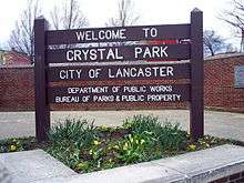
Crystal Park is located in Lancaster, Pennsylvania. Crystal Park’s entrance is located on the intersection of First and Crystal streets. It is encased by First Street on the south, Reo Avenue on the west and Rieker Avenue on the north and east.
It is owned and managed by the City’s Public Works Parks & Public Property Department.[1] There are twenty four parks downtown Lancaster City[2] that are owned and operated as parks and public spaces through the City’s Public Works Parks & Public Property Department. The Park rests in the 10th sector of Lancaster City Pennsylvania, which is on the west end of town.
History

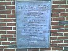
The Park was first dedicated to the public on July 4, 1957. The Land for this Park was donated to the city of Lancaster, Pennsylvania by Mr. and Mrs. Paul D. Eshelman on January 2, 1956.[3] Crystal Park was originally developed by the Department of Parks and Public Property of the City of Lancaster during the period from March to July 1957.[1]
As of July 4, 2007 the Park turned 50 years old.
The Park stands on the ruins of a famous Brewery from the late 1800s. In a stretch of time from 1881 to 1886, Lancaster was known for the beer it turned out. A citizen of Lancaster known as Frank A. Rieker, became Lancaster's most successful brewer.[4] Where the Park stands today, once stood the F.A. Rieker Star Brewery, famous for making some of the first Pilsner Beers.
Tavern Trove quotes the history of the area as:[5]
Frank A. Rieker, Star Brewery (602–606 West King) 1876–1907. Frank A. Rieker Estate (Star Brewery) 1907–1912. F. A. Rieker Brewing Co. 1912–1920. The Brewery had its operations shut down by National Prohibition in 1920–1933. At the time that the Brewery stood where the Park know exists, and turned out over 50,000 barrels of beer a year. They sold most to the local neighborhood, then called "Cabbage Hill". It was served as take out in "growlers" which was a small tin container, from tap to home.[4]
In front of the Park, F.A. Rieker built a Victorian successful bar, known as the F.A. Rieker Western Market Salon & Hotel. The interior was built with Italian Floor tiles and intricate pressed metal ceilings, expensive wood working and custom boilers.[6] The family gave control to the Brewery, in a shady deal to mobsters in the early prohibition years. They illegally ran hoses through the city sewers, to the taps to Lancaster's finest Saloon.[6] Most of the massive, six floor buildings were demolished in 1941; so that the efforts to win World War II could be aided. Eventually the land would be passed on to the park and the Market Saloon & Hotel, would become the now Historic Blue Star Inn, which kept the insides intact.
The Park is a founded on much land where William Penn, the founder of Pennsylvania, actually set aside for the town of Lancaster, PA. This town (which mostly would have been the side of town the park is now on) held much role in the Revolutionary and Civil Wars. It is a matter of a mile from President James Buchanan's house. The area of his house is known as Wheatland[7] and many famous homes, mansions and history are home there. Lancaster City, PA is undergoing a Revitalization; and has plans to revamp this whole side of town.[8][9]
Neighborhood
The neighborhood around the park is rich with history, but unfortunately has been let go over the years. The park is no different. Once the south west side of the town it sits in was considered the nicest living and served as welcoming gates to the city. The neighborhood is racially diverse, but made up of mostly Latino and African American influence. Though there are some very nice homes still left in this part of the city, it has become a refugee of low income families. Drugs, gang activities and general mischief dot this area. The Park unfortunately has taken a hit and neglect because of this.
Historically this area was known as Cabbage Hill[4] Which has much recorded history to itself. Cabbage Hill was a neighborhood of German immigrants into Lancaster. It was settled mostly after the 1840s by people who left Europe for freedom of practice of religion. A lot of Cabbage was grown here, because of the Sauerkraut they produced. This part of the city is a series of hills with steep and often narrow streets that run at southwest angles to the rest of the downtown. Fairfew Avenues was originally called Love Lane. Crystal Street was originally called Brewery Street.[4]
Located a few blocks from the park are several Churches; Pearl Street United Methodist Church, Lancaster Metaphysical Chapel, Glad Tidings Temple and St Luke’s United Church of Christ.
There are also a few eating places within a few blocks of the park; Captain Gus’ Steak Shop, Hit the Spot Pizza, Lee’s Deli. Also DeJesus’ Mini Market, Mangat Mini Market and Latin American Deli Grocery border the surrounding blocks. The only real restaurants in the neighborhood of the park is Jethro’s Restaurant & Bar and Kegel’s Seafood Restaurant. There are three bars in the area; most well known is the Historic Blue Star Inn; bordering the north side of Crystal Park (Which was part of the Brewery that once was based on the parks land), as well as the bar at Jethro’s Restaurant and the Manor Tavern.
The Park area once featured many businesses in the area, but has seen a decline in the years. On the top border of the park is a Used Furniture & Antique Store between the Park and King Street. Kunzler & Company, Inc. is located about 5 blocks from the park. There also is a garage, called Jones’ Garage, just a few blocks from the park.
Lancaster City is serviced by Amtrak, Greyhound Lines, Capitol Trailways and the Red Rose Transit Authority, however the park is only serviced by bus. The park does not have a direct stop at it, but several buses come close. Red Rose Transit’s Route 3 (Park City C/8th Ward), Route 4 (Elm Avenue/Parkside), and Route 16 (Millersville) all come close. the Lancaster Newspaper has reported also that RRTA's Ride to work program serves this area.[10]
The police frequent the area. It is patrolled and responded to by the City of Lancaster’s, City Police. The Lancaster City Police lists crimes reported by sector on their website. The park is in sector 10.
The Vineyard Church of Lancaster is known to have just created a "adopt a park" deal with the Public Works Department, to help maintain the park and care for its neighborhood. The Partnership between the Vineyard Church of Lancaster and the Neighborhood is known as the Friends of Crystal Park Project.
Friends of Crystal Park
The Friends of Crystal Park is a collective of dedicated individuals, families, and businesses in the area surrounding Crystal Park who are committed to the care, upkeep and safety of the park and the surrounding community.[11]
The Friends of Crystal Park started in late 2007, when local dedicated individuals out of the Vineyard Church of Lancaster, who had history to this side of town adopted Crystal Park. In the early planning stages they contacted the Public Works of Lancaster's City Parks Department. They expressed their care for the neighborhood and their desires to be dedicated to the care, upkeep and preservation of Crystal Park through incorporating the neighborhood. After receiving the go ahead from the Lancaster City's Park Department; Friends of Crystal Park was born. The Friends of Crystal Park from the beginning has been about; "Neighbors Helping Neighbors to build a better Neighborhood".[11]
The Neighborhood / Vineyard Church of Lancaster partnership that is the Friends of Crystal Park, has already planned several successful park cleanup events and flower plants. They hope to see more community based events and activities in the park, as well as more park cleanups.[11]
The Friends of Crystal Park was created to help the Lancaster City's Park Department, by filling in the void where they can; because they understand the Parks Department is busy and cannot be all things in all places. So the F.O.C.P have come alongside to offer their help for a community they live, work and play in as well as willing to care for.[11]
References
- 1 2 Lancaster City: Public Works. Cityoflancasterpa.com (2008-11-24). Retrieved on 2011-02-23.
- ↑ Lancaster City: Parks Map. Cityoflancasterpa.com. Retrieved on 2011-02-23.
- ↑
- 1 2 3 4 Cabbage Hill History. Homepage.mac.com. Retrieved on 2011-02-23.
- ↑
- 1 2
- ↑ Welcome to LancasterHistory.org. Wheatland.org. Retrieved on 2011-02-23.
- ↑ Southwest Revitalization Initiatives for the city of Lancaster, Pennsylvania, November 7, 2007
- ↑ City of Lancaster. Cityoflancasterpa.com (2008-11-24). Retrieved on 2011-02-23.
- ↑ RRTA Access to Jobs program gets $30,000 – LancasterOnline.com Business. Local.lancasteronline.com (2008-10-03). Retrieved on 2011-02-23.
- 1 2 3 4 Home. Friends of Crystal Park. Retrieved on 2011-02-23.
External links
Coordinates: 40°02′12″N 76°19′01″W / 40.0368°N 76.3170°W