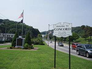
Concord, Staten Island
Concord is a neighborhood located in the borough of Staten Island in New York City, New York, United States.

Located in northeastern Staten Island, and bordered by the neighborhoods of Grasmere, Clifton, Dongan Hills, Emerson Hill, and Old Town, Concord was named Dutch Farms originally, but was renamed in 1845 after Concord, Massachusetts as a consequence of that town's historical significance. Early residents of Concord included Judge William Emerson (brother of Ralph Waldo Emerson and for whom nearby Emerson Hill is named) and Henry David Thoreau. In the early 19th Century, Concord had a significant German immigrant population that was dominant. Today, it is ethnically diverse.[1]
Concord currently consists of one-family homes, small apartment buildings, and condominiums. The neighborhood’s center is traversed by some of the most heavily traveled roads on Staten Island, including Clove Road; Richmond Road; Targee Street; and the Staten Island Expressway.[1]
Much property in Concord was condemned to make way for the Staten Island Expressway in the early 1960s; one of its principal east-west thoroughfares, Price Street, is now a service road of the expressway and is known as Narrows Road North. In its first year of existence — 1961-62 — Monsignor Farrell High School operated out of an annex of St. Sylvester's Elementary School in Concord while the construction of its permanent campus in Oakwood was being completed.
In 1985, Staten Island's first mosque opened in Concord; it later moved to Tompkinsville, however. A small public alternative high school, named Concord High School, is located in the neighborhood, which is also home to a large medical arts complex (on Ralph Place) that had sprung up around the former Doctor's Hospital of Staten Island, which closed in 2003.
Education
Concord is served by P.S.48 on Targee Street and Concord HS on Rhine Avenue.
Transportation
Concord is served by the S74/S76 buses on Targee Street, the S53/S93 on Clove Road/Narrows Road, and the X10, X14, and X15 express buses to Manhattan.
 |
Grymes Hill & Stapleton Heights | Clifton & Stapleton | Rosebank |  |
| Grymes Hill, Emerson Hill & Dongan Hills | |
Rosebank & Grasmere | ||
| ||||
| | ||||
| Old Town & Dongan Hills | Old Town | South Beach |
References
- 1 2 Kenneth T. Jackson: The Encyclopedia of New York City: The New York Historical Society; Yale University Press; 1995. P. 272.
Coordinates: 40°36′30″N 74°05′04″W / 40.60833°N 74.08444°W