Colorado State Highway 209
| ||||
|---|---|---|---|---|
| South Higgins Avenue | ||||
|
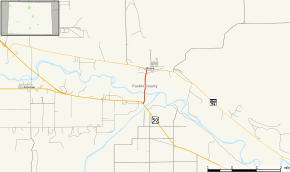
Map of Pueblo County in south central Colorado with SH 209 highlighted in red | ||||
| Route information | ||||
| Maintained by CDOT | ||||
| Length: | 1.528 mi[1] (2.459 km) | |||
| Location | ||||
| Counties: | Pueblo | |||
| Highway system | ||||
|
Colorado State Highways
| ||||
State Highway 209 is a highway in Pueblo County, Colorado. SH 209 starts at a junction with US 50 and ends at a junction with SH 96 in Boone.
Route description
SH 209 runs 1.5 miles (2.4 km), beginning heading perpendicular away from US 50 south of Boone. South Higgins Avenue, what the highway is named at this point, turns slightly from northeast to north as it heads through a farmland terrain. The route crosses the Arkansas River as well as another one of its tributaries before entering Boone. Meeting First Street, the roadway comes to an end without continuation at SR 96, Main Street.[2]
Major intersections
The entire route is in Pueblo County.
| Location | mi | km | Destinations | Notes | |
|---|---|---|---|---|---|
| | 0.000 | 0.000 | |||
| Boone | 1.528 | 2.459 | |||
| 1.000 mi = 1.609 km; 1.000 km = 0.621 mi | |||||
References
- ↑ "Segment list for SH 209". Retrieved 2011-01-23.
- ↑ Google (July 16, 2011). "SH 209" (Map). Google Maps. Google. Retrieved July 16, 2011.
External links
This article is issued from Wikipedia - version of the 11/12/2016. The text is available under the Creative Commons Attribution/Share Alike but additional terms may apply for the media files.

