Chester Creek (Alaska)
| Chester Creek | |
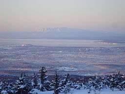 Overview of Anchorage, Chester Creek is on the right hand side | |
| Country | United States |
|---|---|
| State | Alaska |
| Municipality | Anchorage |
| Source | |
| - location | Chugach Mountains |
| Mouth | Knik Arm, Cook Inlet |
| - coordinates | 61°12′30″N 149°55′29″W / 61.20833°N 149.92475°WCoordinates: 61°12′30″N 149°55′29″W / 61.20833°N 149.92475°W |
| Length | 21 mi (34 km) |
| Basin | 30.5 sq mi (79 km2) |
| Discharge | for Arctic Blvd |
| - average | 21 cu ft/s (0.6 m3/s) |
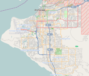
 Location of the mouth of the Chester Creek in Alaska
| |
Chester Creek is one of several streams that flow through the city of Anchorage, Alaska. It runs for 21 miles (34 km) from the Chugach Mountains to the Knik Arm of Cook Inlet.[1][2]
The creek connects a number of parks, open spaces and lakes to form a green corridor running from east to west through the city. A paved trail follows the creek for part of its course through the areas from Goose Lake to Westchester Lagoon.
The watershed of the Chester Creek includes a number of tributaries, the upper reaches are known as the South Fork which is located within Fort Richardson of the Joint Base Elmendorf–Richardson base. The Middle Fork emerges from Russian Jack Springs in the park of the same name, the North Fork drains a smaller area to the west of the Middle Fork, and the Lower Chester Creek is the area downstream of the confluence of the North and South Forks to the outlet of Westchester Lagoon into the Knik Arm.[2]
History
Before English speaking settlers came into the area, the Dena'ina were the inhabitants. They were known to use Chanshtnu, or Grass Creek, as a salmon fishing camp. The word Chanstnu was later transcribed to Chester, giving us the name we now use.[3][4]
The areas surrounding the creek were developed as Anchorage expanded east in the first half of the 20th century, although some portions were also designated as green spaces. In 1971, as part of the reconstruction following the 1964 Alaska earthquake, existing parks were connected with other land, older plots and some new purchases, to create one of the oldest urban greenbelts in the country, connecting Russian Jack Springs to Cook Inlet. This included the area around the outlet of the creek which had subsided during the earthquake, which meant that it now became partly submerged at high tide. The decision was made to create a lake protected from the sea by a new embankment, to form the Westchester lagoon, with the remaining area being rehabilitated as parkland.[5][6]
Chester Creek Trail
Like its designation as a greenbelt, the development of the trail into an integrated exercise and transit thoroughfare was pushed by activist citizens. Lanie Fleischer, in 1972, organized the Anchorage Bike Committee with a cohort of other Anchorage citizens. After a successful 'bike in' that drew some 300 residents, city planners began to move forward with a dedicated pedestrian path along the Chester Creek in 1973.[7] This was the first of what was to become a network of multi-use trails within the city.[8]
Renamed the Lanie Fleischer Chester Creek Trail in 1994, the four mile long trail is popular with cyclists in summer, and skiers in winter. A comprehensive three year improvement project for the trail, with an estimated cost of US$ 3.2 million, began in 2012.[9][10]
During the summer of 2015 the trail became the subject of a week-long interaction between a group of artists and users of the trail. The project called Seeking the Source, was aimed at finding out what experiences and recollections the residents of Anchorage had about the trail, and what part it plays in shaping perceptions of the local geography, its wildlife and community.[11]
Wildlife
The creek fosters a diverse range of flora and fauna, which includes migrating fish, large mammals such as moose and bears, and wildfowl which are a feature of the various lakes.[2]
In the 1970s the original free-flowing outlet of the creek was modified with the construction of the dam and outlet structure forming Westchester Lagoon, this alteration and later modifications, meant that Coho salmon and Dolly Varden trout were prevented from easily entering the creek.[2]
Following changes to the dam outlet in 2009 to one that was fish-friendly, the numbers of Coho and Pink salmon passing into the creek increased dramatically, over 2000 fish were logged in 2013 compared to less than 500 in 2008. There are also efforts in place to revitalize the creek as a habitat for these salmon species through integrated works by the United States Fish and Wildlife Service and the Anchorage Office of Fish and Game.[12]
There is a large moose habitat that incorporates parts of the creek. In order to better serve these animals, efforts are being made to eradicate the Mayday trees which although attractive, are not a beneficial food source for the animals.[5]
Hydrology
The streamflow of the Chester Creek has been measured by the USGS since 1966. The stream gauge site near the Arctic Boulevard bridge measures 90% of the watershed, specifically 27.4 square miles (71 km2) of the total 30.5 square miles (79 km2).[13][2]
The mean flow between 1966 and 2013 was 21.2 cubic feet per second (0.60 m3/s), with the lowest daily flow recorded in February 1975 at 1.6 cubic feet per second (0.045 m3/s). The highest creek level recorded occurred in September 2012 with a height of 5.9 feet (1.8 m) through the gauge, giving a corresponding flow of 454 cubic feet per second (12.9 m3/s).[13]
See also
References
- ↑ U.S. Geological Survey Geographic Names Information System: Chester Creek
- 1 2 3 4 5 Draft Chester Creek Watershed Plan (PDF). Municipality of Anchorage. September 2014. pp. 1–23.
- ↑ William Bright (2004). Native American Placenames of the United States. University of Oklahoma Press. pp. 94–. ISBN 978-0-8061-3598-4.
- ↑ "In push for Alaska Native place names, a boost from a digital atlas". Alaska Dispatch News. 8 November 2015. Retrieved 14 January 2016.
- 1 2 "Lanie Fleischer Chester Creek Trail" (PDF). Historic American Landscapes Survey. National Park Service. Retrieved 24 January 2016.
- ↑ National Research Council (U.S.). Committee on the Alaska Earthquake (1968). The Great Alaska Earthquake of 1964. National Academies. pp. 203–. NAP:12982.
- ↑ "Nan Elaine (Lanie) Fleischer". Alaska Women's Hall of Fame. Retrieved 14 January 2016.
- ↑ Wohlforth, Charles P. (25 February 2011). Alaska For Dummies. John Wiley & Sons. pp. 188–. ISBN 978-1-118-03048-6.
- ↑ "Chester Creek Trail Improvements". Parks and Recreation. Municipality of Anchorage. Retrieved 14 January 2016.
- ↑ "Chester Creek Trail". Alaska Channel. Retrieved 14 January 2016.
- ↑ "'Seeking the Source' of Anchorage's Trails and Their Community". Alaska Public Media. 20 May 2015. Retrieved 25 January 2016.
- ↑ "Silver salmon stage a revival in urban Chester Creek". Alaska Dispatch News. 21 October 2014. Retrieved 24 January 2016.
- 1 2 "USGS Chester Creek" (PDF). National Water Information System. U.S. Geological Survey. 1966–2013. Retrieved 14 January 2016.