Chauvigny
| Chauvigny | ||
|---|---|---|
|
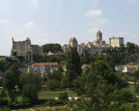
A general view of Chauvigny | ||
| ||
 Chauvigny | ||
|
Location within Nouvelle-Aquitaine region  Chauvigny | ||
| Coordinates: 46°34′10″N 0°38′51″E / 46.5694°N 0.6475°ECoordinates: 46°34′10″N 0°38′51″E / 46.5694°N 0.6475°E | ||
| Country | France | |
| Region | Nouvelle-Aquitaine | |
| Department | Vienne | |
| Arrondissement | Montmorillon | |
| Canton | Chauvigny | |
| Government | ||
| • Mayor (2001–2008) | Gérard Herbert | |
| Area1 | 95.82 km2 (37.00 sq mi) | |
| Population (2006)2 | 7,050 | |
| • Density | 74/km2 (190/sq mi) | |
| Time zone | CET (UTC+1) | |
| • Summer (DST) | CEST (UTC+2) | |
| INSEE/Postal code | 86070 / 86300 | |
| Elevation | 61–149 m (200–489 ft) | |
|
1 French Land Register data, which excludes lakes, ponds, glaciers > 1 km² (0.386 sq mi or 247 acres) and river estuaries. 2 Population without double counting: residents of multiple communes (e.g., students and military personnel) only counted once. | ||
Chauvigny is a commune in the Vienne department in the Nouvelle-Aquitaine region in western France.
Chauvigny is located 20 miles (32 km) east of Poitiers by rail. The town is situated overlooking the Vienne River and a small brook. Chauvigny is twinned with Billericay in Essex, England.
Sights
Chauvigny features two interesting Romanesque churches, both restored in the 19th century. There are also ruins of a château of the bishops of Poitiers, and of several other strongholds.
Near Chauvigny is the curious bone-cavern of Jioux, the entrance to which is fortified by large blocks of stone.[1]
Economy
As of 1911, the town carried on lime-burning and plaster-manufacture, and there were stone quarries in the vicinity. Trade was in wool and feathers.[1]

See also
References
- 1 2
 Chisholm, Hugh, ed. (1911). "Chauvigny". Encyclopædia Britannica. 6 (11th ed.). Cambridge University Press. p. 19.
External links
| Wikimedia Commons has media related to Chauvigny. |
- Official site
- Tourism
- Philosophical Society
- Spectacle animalier: Les géants du Ciel
- Flying club
- IREO - Institut de Formation de Chauvigny
- Shooting club
- Romanes.com
- Aerial views

.svg.png)