Chuspi (Ancash)
For the mountain on the border of the Lima Region and the Pasco Region, Peru, see Ch'uspi.
| Chuspi | |
|---|---|
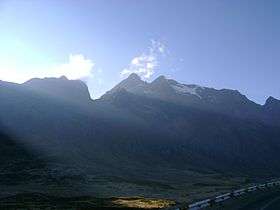 Chuspi as seen from the northwest | |
| Highest point | |
| Elevation | 5,090 m (16,700 ft) [1] |
| Coordinates | 9°53′46″S 77°03′16″W / 9.89611°S 77.05444°WCoordinates: 9°53′46″S 77°03′16″W / 9.89611°S 77.05444°W |
| Geography | |
 Chuspi Peru | |
| Location | Peru, Ancash Region |
| Parent range | Andes, Wallanka |
Chuspi or Ch'uspi (Quechua for insect, generic name of flies or two-winged insects; fly,[2] also spelled Chuspi or Chuspic)[1][3] is a 5,090-metre-high (16,700 ft) mountain in the north of the Huallanca mountain range in the Andes of Peru. It is located in the Ancash Region, Bolognesi Province, in the districts of Aquia and Huallanca.
References
- 1 2 Alfred J. Bodenlos, George E. Ericksen, Lead-Zing Deposits of Cordillera Blanca and Northern Cordillera Huayhuash, Peru, Geological Survey Bulletin 1017, see. sketch maps p.9-10
- ↑ Teofilo Laime Ajacopa, Diccionario Bilingüe Iskay simipi yuyayk'ancha, La Paz, 2007 (Quechua-Spanish dictionary)
- ↑ escale.minedu.gob.pe - UGEL map of the Bolognesi Province (Ancash Region)
This article is issued from Wikipedia - version of the 8/29/2016. The text is available under the Creative Commons Attribution/Share Alike but additional terms may apply for the media files.