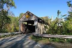
Burkeville Covered Bridge
|
Burkeville Covered Bridge | |
|
Burkeville Covered Bridge | |
  | |
| Location | Conway, Massachusetts |
|---|---|
| Coordinates | 42°30′28″N 72°42′40″W / 42.50778°N 72.71111°WCoordinates: 42°30′28″N 72°42′40″W / 42.50778°N 72.71111°W |
| Built | 1870 |
| Architect | Sherman,Sylvanus P. |
| Architectural style | Other |
| NRHP Reference # | [1] |
| Added to NRHP | September 9, 1988 |
The Burkeville Covered Bridge is a historic covered bridge in Conway, Massachusetts. It is a rare example of a multiple kingrod bridge with iron tensioning verticals (a modified Howe truss system), and one of a few 19th century covered bridges to survive in Massachusetts. The bridge was built in 1870 after the previous bridge on the site (in the Burkeville section of Conway) was damaged in a flood.[2] The bridge carries Main Poland Road over the South River, just south of Massachusetts Route 116 west of Conway Center. Its roof partially collapsed under heavy snow in 1975, but was restored by town volunteers.[2] It was closed for safety reasons in 1985, and reopened to vehicular traffic in November 2013 after renovations.[3] The bridge was listed on the National Historic Register in 1988.[1]
See also
- National Register of Historic Places listings in Franklin County, Massachusetts
- List of bridges on the National Register of Historic Places in Massachusetts
- Arthur A. Smith Covered Bridge, Colrain
References
- 1 2 National Park Service (2008-04-15). "National Register Information System". National Register of Historic Places. National Park Service.
- 1 2 "MACRIS inventory record for Burkeville Covered Bridge". Commonwealth of Massachusetts. Retrieved 2013-12-20.
- ↑ "Conway covered bridge reopens". The Recorder. November 17, 2013. Retrieved 2013-12-20.

