Buka Passage

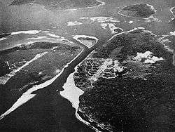
A 1943 aerial photograph of the Buka Passage between Bougainville (left) and Buka (right) islands
Buka Passage is a narrow strait that separates Buka Island from the northern part of Bougainville Island in Papua New Guinea. A number of shipwrecks are located in the passage.
The aerial photograph on the right, taken in 1943, shows the Buka Passage between Bougainville and Buka islands. Two Japanese airfields are visible, Buka Airfield (center) and Bonis Airfield (left). Today, Buka Airfield has become Bougainville's major airport, whereas Bonis Airfield has been disused since World War II.
Coordinates: 5°25′48″S 154°40′37″E / 5.430°S 154.677°E
This article is issued from Wikipedia - version of the 9/27/2015. The text is available under the Creative Commons Attribution/Share Alike but additional terms may apply for the media files.