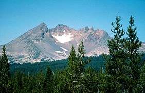
Broken Top
| Broken Top | |
|---|---|
|
| |
| Highest point | |
| Elevation | 9,179 ft (2,798 m) NAVD 88[1] |
| Prominence | 2,175 ft (663 m) [1] |
| Coordinates | 44°04′58″N 121°41′59″W / 44.0828931°N 121.6997595°WCoordinates: 44°04′58″N 121°41′59″W / 44.0828931°N 121.6997595°W [2] |
| Geography | |
| Location | Deschutes County, Oregon, U.S. |
| Parent range | Cascade Range |
| Topo map | USGS Broken Top |
| Geology | |
| Age of rock | Pleistocene |
| Mountain type | Stratovolcano |
| Volcanic arc | Cascade Volcanic Arc |
| Last eruption | About 100,000 years ago[3] |
Broken Top is an extinct, glacially eroded stratovolcano in Oregon,[4] part of the extensive Cascade Range. Located southeast of the Three Sisters peaks, the volcano, residing within the Three Sisters Wilderness,[5] is 20 miles (32 km) west of Bend, Oregon in Deschutes County. Eruptive activity stopped roughly 100,000 years ago, and currently, erosion by glaciers has reduced the volcano's cone to where its contents are exposed. Bend and Crook Glaciers are the two named glaciers on the peak.
Geology

Due to extensive erosion, the contents of Broken Top's cone are exposed, which allows volcanologists to classify Broken Top as a complex stratovolcano.[4] Its initial eruptions during the Pleistocene, consisting of basaltic andesite lava, contributed to a base shield. The center of this edifice consists of agglomerate, which was oxidized, and intrusive dikes and geologic sills.[4] Erratic eruptions continued afterward, erupting silicic lava. Much of the current cone is occupied by flows of andesite, dacite, rhyodacite, and pyroclastic flows; these deposits extending from the subordinate volcano to the summit. The volcanic crater, now 0.8 km, was most likely created through subsidence.[4]
Wilderness
Broken Top resides in the Three Sisters Wilderness, which makes up 242,000 acres (980 km2) of the Willamette National Forest. About the area, there are geologic features such as Collier Glacier, Rock Mesa, Collier Cone, and Yapoah Crater.
Permits for average entry are distributed, free, from Memorial Day (May 31)–Halloween (October 31).[6] To gain access to the Obsidian area of the wilderness, special entry is required, for both day and overnight hikers.[6] These passes are distributed only at McKenzie Ranger District in Willamette Forest and Sisters Ranger District in Deschutes Forest.[6] The administration disallows any vehicle entry.
See also
References
- 1 2 "Broken Top". Peakbagger.com. Retrieved 2009-06-30.
- ↑ "Broken Top". Geographic Names Information System. United States Geological Survey. Retrieved 2008-03-31.
- ↑ "Broken Top Volcano". Deschutes & Ochoco National Forests. USDA Forest Service. 2003-11-26. Archived from the original on 2010-11-09. Retrieved 2008-03-18.
- 1 2 3 4 Wood, Charles A.; Jürgen Kienle (1993). Volcanoes of North America. Cambridge University Press. p. 183. ISBN 0-521-43811-X.
- ↑ "Three Sisters Wilderness". Willamette National Forest. United States Forest Service. 2004-07-29. Archived from the original on 2010-08-06. Retrieved 2008-05-18.
- 1 2 3 "Wilderness Permits". United States Forest Service. May 24, 2006. Archived from the original on 2010-10-05. Retrieved 2009-07-06.
External links
| Wikimedia Commons has media related to Broken Top. |
- "Broken Top". SummitPost.org. Retrieved 2011-05-07.
- "Broken Top". SkiingtheBackcountry.org. Retrieved 2009-12-07.
- "Broken Top". Global Volcanism Program. Smithsonian Institution. Retrieved 13 September 2016.
