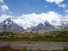
Braldu River
| Braldu River برالڑو ندی | |
| River | |
 The Braldu River, with the Baltoro Glacier in the background | |
| Country | Pakistan |
|---|---|
| State | Gilgit Baltistan |
| Region | Kashmir |
| District | Skardu |
| Source | 35°41′31″N 76°10′20″E / 35.691982°N 76.172345°ECoordinates: 35°41′31″N 76°10′20″E / 35.691982°N 76.172345°E |
| - location | Baltoro Glacier and Biafo Glacier, Skardu |
| - elevation | 3,620 m (11,877 ft) |
| Mouth | 35°39′20″N 75°29′09″E / 35.655482°N 75.485771°E |
| - location | Basha Basna River to form Shigar River at Tigstun, Skardu |
| - elevation | 2,330 m (7,644 ft) |
| Length | 78 km (48 mi) |
| Discharge | |
| - average | 265 m3/s (9,358 cu ft/s) |
The Braldu River (Urdu: برالڑو ندی) flows in the Skardu District of Gilgit Baltistan in Pakistan. The Braldu River joins the Basha Basna River, and together they form the Shigar River, which is a tributary of the Indus River.[1][2]
Geography
The Braldu River is a 78 kilometres (48 mi) long river, that originates from the Baltoro Glacier[1] and flows 25 kilometres (16 mi) to the west where it receives melt waters from the Biafo Glacier.[1] The Baltoro Glacier and the Biafo Glacier are among the largest glaciers outside the polar regions. The Baltoro Glacier give rise to the four Eight-thousanders mountain peaks, among them is the K2 28,251 ft (8,611 metres), the second highest mountain peak of the world.[3] The Biafo Glacier holds the Snow Lake, which is 61 mile (100 km) river of ice, it is among the world's longest continuous glacier systems outside of the polar regions.[4]
The Braldu River flows almost eastwards, entirely in the Skardu District of Baltistan and forms the Braldu Valley. The most remote settlement in the valley is the village of Askole, situated at the right bank of the Braldu River. Askole serves as the base camp for mountaineering expeditions and trekking to the various glaciers in this Karakoram Range.[5] Many glacier fed streams joins the Braldu River in the Braldu Valley.
The Braldu River flows through the towns of Korphe, Shamang, Barjand, Kharwa, Niyil and Tingstun. It merges with the Basha Basna River 5 kilometres (3.1 mi) before Tingstun to form the Shigar River at the end of the Braldu Valley.[2][6] The Basha Basna River originates from the Chogo Lungma and the Sokha Glaciers, flows southeastwards. The Shigar River joins the Indus River at Skardu, 48 kilometres (30 mi) from the merger of the Braldu River and the Basha Basna River.[2]
Kayaking
The Braldu River is considered to be a super extreme whitewater river. It provides great scope for kayaking, which is practised during the summer from June to August. The first attempt to kayak the river was made in 1978 by a British expedition led by Mike Jones. Jones lost his life trying to rescue a team mate, for which he was awarded the Queen's Gallantry Medal (QGM).[7][8]
Image gallery
- Downstream end of Baltoro Glacier, with Braldu River emerging from underneath
 The Braldu River, with the Biafo Glacier in the background
References
- 1 2 3 Mohan C. Bhandari (2006). Solving Kashmir. Lancer Publishers, 2006. p. -15,16. ISBN 978-81-7062-125-6. Retrieved 31 August 2012.
- 1 2 3 C. R. Beesley (2004). Pakistan: minerals, mountains & majesty. Lapis International, 2004. p. -86, 87. ISBN 978-0-9715371-4-9. Retrieved 31 August 2012.
- ↑ "BROAD PEAK AND CHOGOLISA, 1957". himalayanclub. Retrieved 2012-09-13.
- ↑ David Mazel (1994). Mountaineering Women: Stories by Early Climbers. Texas A&M University Press, 1994. p. -103. ISBN 978-0-89096-617-4. Retrieved 31 August 2012.
- ↑ Appalachian Mountain Club (1994). Appalachia, Volume 50. Appalachian Mountain Club, 1994. p. -47. Retrieved 31 August 2012.
- ↑ John Sinkankas (1989). Emerald and other beryls. Geoscience Press, 1989. p. -488. ISBN 978-0-945005-03-2. Retrieved 31 August 2012.
- ↑ Jamie Benidickson (1997). Idleness, Water, and a Canoe: Reflections on Paddling for Pleasure. University of Toronto Press, 1997. p. -108. ISBN 978-0-8020-7910-7. Retrieved 31 August 2012.
- ↑ "Baillie's proud canoeing legacy". royalcanoeclub.com. Retrieved 2012-08-31.