Bilyar Point
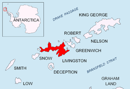
Bilyar Point (Bulgarian: нос Биляр, ‘Nos Bilyar’ \'nos bi-'lyar\) is a rounded ice-free point on the north coast of western Livingston Island in the South Shetland Islands, Antarctica projecting 350 m into Barclay Bay. Situated northwest of Rotch Dome, 3 km southwest of Rowe Point, 4.5 km east-northeast of Lair Point, and 1.7 km northeast of Nedelya Point.
The point is named after the medieval city of Bilyar, capital of Volga Bulgaria in 12-13th Century AD.
Location
Bilyar Point is located at 62°36′12″S 60°56′58″W / 62.60333°S 60.94944°WCoordinates: 62°36′12″S 60°56′58″W / 62.60333°S 60.94944°W. British mapping in 1968, Chilean in 1971, Argentine in 1980, Spanish in 1993 and Bulgarian in 2005 and 2009.
Maps
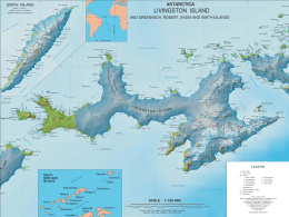
- L.L. Ivanov et al. Antarctica: Livingston Island and Greenwich Island, South Shetland Islands. Scale 1:100000 topographic map. Sofia: Antarctic Place-names Commission of Bulgaria, 2005.
- L.L. Ivanov. Antarctica: Livingston Island and Greenwich, Robert, Snow and Smith Islands. Scale 1:120000 topographic map. Troyan: Manfred Wörner Foundation, 2009. ISBN 978-954-92032-6-4
References
This article includes information from the Antarctic Place-names Commission of Bulgaria which is used with permission.