Betafo District
For the town, see Betafo. For the village in Arivonimamo, see Betafo, Arivonimamo
| Betafo | |
|---|---|
| District | |
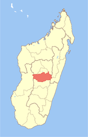
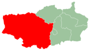 Location of the district within the region of Vakinankaratra. | |
| Country |
|
| Region | Vakinankaratra |
| Administrative centre | Betafo |
| Area | |
| • Total | 4,155.03 km2 (1,604.27 sq mi) |
| Population (2013)[1] | |
| • Total | 254,740 |
| • Density | 61/km2 (160/sq mi) |
Betafo is a district in Vakinankaratra Region, Madagascar. The administrative centre of the district is the town of Betafo. In 2001, the district had an estimated 301,671 inhabitants,[1] and was divided into 18 communes. However the district has subsequently been divided by the creation of the new Mandoto District from former parts of Betafo District. The reduced district covers an area of 4,155.03 sq.km, and it had an estimated population of 254,736 in mid 2013.[2]
The irrigated rice paddies of the district are emblematic of this technology throughout the highlands and were nominated to the Tentative List of UNESCO World Heritage Sites in Madagascar in 1997.[3]
References
- 1 2 "Collectivité malgache".
- ↑ Institut National de la Statistique, Antananarivo.
- ↑ UNESCO. "World Heritage Convention: Madagascar". Archived from the original on April 25, 2011. Retrieved April 25, 2011.
Coordinates: 19°50′24″S 46°51′18″E / 19.84°S 46.855°E
This article is issued from Wikipedia - version of the 10/31/2016. The text is available under the Creative Commons Attribution/Share Alike but additional terms may apply for the media files.