Autrans
| Autrans | ||
|---|---|---|
 | ||
| ||
 Autrans | ||
|
Location within Auvergne-Rhône-Alpes region  Autrans | ||
| Coordinates: 45°10′34″N 5°32′31″E / 45.176°N 5.542°ECoordinates: 45°10′34″N 5°32′31″E / 45.176°N 5.542°E | ||
| Country | France | |
| Region | Auvergne-Rhône-Alpes | |
| Department | Isère | |
| Arrondissement | Grenoble | |
| Canton | Fontaine-Vercors | |
| Intercommunality | Massif du Vercors | |
| Government | ||
| • Mayor (2014–2020) | Thierry Gamot | |
| Area1 | 44 km2 (17 sq mi) | |
| Population (2010)2 | 1,702 | |
| • Density | 39/km2 (100/sq mi) | |
| Time zone | CET (UTC+1) | |
| • Summer (DST) | CEST (UTC+2) | |
| INSEE/Postal code | 38021 / 38880 | |
| Elevation | 1,005–1,711 m (3,297–5,614 ft) | |
|
1 French Land Register data, which excludes lakes, ponds, glaciers > 1 km² (0.386 sq mi or 247 acres) and river estuaries. 2 Population without double counting: residents of multiple communes (e.g., students and military personnel) only counted once. | ||
Autrans is a former commune in the Isère department in the Rhône-Alpes region of south-eastern France. On 1 January 2016, it was merged into the new commune of Autrans-Méaudre-en-Vercors.[1]
At the 1968 Winter Olympics in Grenoble, it hosted the biathlon, cross country skiing, Nordic combined, and the ski jumping normal hill events.[2]
The inhabitants of the commune are known as Autranais or Autranaises.[3]
The commune has been awarded one flower by the National Council of Towns and Villages in Bloom in the Competition of cities and villages in Bloom.[4]
Geography
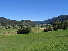
Autrans is located on the Vercors Plateau in the Vercors Regional Natural Park some 10 km west of Grenoble and 11 km east of Vinay. Access to the commune is solely by the D106C which branches north from the D106 and passes in a loop through the village then back south to Méaudre. A local road goes north from the village along to the valley to the ski fields in the north of the commune. There is farmland in the valley but the slopes of the surrounding mountains are rugged and heavily forested.[5]
The Meaudret rises in the north of the commune and flows south down the valley through the village and continues south to join the Bourne at Les Jarrands.
Bus line 5120 connects Lans-en-Vercors and Villard-de-Lans stops in Autrans village and Méaudre (the square).[6] There is a shuttle bus in winter from the village to the ski fields.
Hiking trails
There are two main hiking trails crossing the commune: municipality is crossed by
- the GR 9;
- the GR footpath: Tour of the Four Mountains.
Places and hamlets[7]
- L'Achard
- Les Ronins
- Les Prud'hommes
- Villeneuve
- Eybertière
- Le Bourg du-dessus
- Les Eperouses
- Le Bourg du dessous
- Le Bouchet
- Le Truc
- Andrevière
- Les Gonnets
- Les Tranchants
- Les Vernes
- Les Gaillards
- Le Mollaret
- Le Tonkin
- Les Franques
- Payenat
- Écharlière
Neighbouring communes and villages
 |
La Rivière | Montaud | Sassenage |  |
| Saint-Gervais | |
Engins | ||
| ||||
| | ||||
| Izeron | Méaudre | Lans-en-Vercors |
Toponymy
The name Autrans is derived from the name of a village called Lans (the oldest village on the plateau) and originated from oultre-Lans meaning "beyond the village of Lans" which, over the course of time, was transformed into Autrans.
History

- The 1968 Olympics in Grenoble (which were the first to be aired on TV) included cross-country skiing, biathlon, ski-jumping (90m ski-jump) and combined Nordic skiing (jumping and cross-country). For many French people the TV images of Nordic skiing at Autrans were a revelation. This would mark the beginning of the development of skiing in France and throughout Europe;
- The Grenoble Olympic Winter Games 1968 ski-jumps were part of a long local tradition of ski jumping (first ski competition in 1911). Today jumps of 90 m, 56 m, and 20 m are equipped to be used in winter and in summer for many national and international competitions. There is a viewing platform at the top of the 90 m ramp.
Heraldry
 |
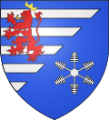
Blazon: Party per bend sinister, at 1 barry of 10 Azure and Argent debruised by a lion of Gules armed, langued, and crowned in of Or; at 2 Azure a crystal of snow Argent. |
Administration

List of Successive Mayors[8]
| From | To | Name | Party | Position |
|---|---|---|---|---|
| 1977 | 1983 | Gilbert Michel | ||
| 1983 | 2008 | Jean Faure | UMP | Senator (1983-2011) |
| 2008 | 2014 | Gabriel Tatin | DVG | 1st VP of Parc |
| 2014 | 2020 | Thierry Gamot | UMP |
(Not all data is known)
Public services

The commune has the following services:
- A Tourist office;
- A Fire Station;
- An Isere General Council road maintenance depot
Twinning
Autrans has twinning associations with:[9]
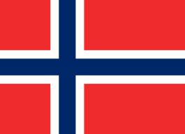
 Lillehammer (Norway) since 1994.
Demography
In 2010 the commune had 1,702 inhabitants. The evolution of the number of inhabitants is known from the population censuses conducted in the commune since 1793. From the 21st century, a census of communes with fewer than 10,000 inhabitants is held every five years, unlike larger communes that have a sample survey every year.[Note 1]
| 1793 | 1800 | 1806 | 1821 | 1831 | 1836 | 1841 | 1846 | 1851 |
|---|---|---|---|---|---|---|---|---|
| 1,001 | 1,100 | 1,103 | 1,047 | 1,107 | 1,117 | 1,181 | 1,219 | 1,290 |
| 1856 | 1861 | 1866 | 1872 | 1876 | 1881 | 1886 | 1891 | 1896 |
|---|---|---|---|---|---|---|---|---|
| 1,201 | 1,204 | 1,173 | 1,118 | 1,092 | 1,071 | 999 | 1,000 | 961 |
| 1901 | 1906 | 1911 | 1921 | 1926 | 1931 | 1936 | 1946 | 1954 |
|---|---|---|---|---|---|---|---|---|
| 946 | 926 | 901 | 801 | 808 | 890 | 857 | 1,114 | 1,359 |
| 1962 | 1968 | 1975 | 1982 | 1990 | 1999 | 2006 | 2010 | - |
|---|---|---|---|---|---|---|---|---|
| 980 | 988 | 1,330 | 1,370 | 1,406 | 1,541 | - | 1,702 | - |
Sources : Ldh/EHESS/Cassini until 1962, INSEE database from 1968 (population without double counting and municipal population from 2006)

Economy
Winter Sports

- Alpine ski area: a large field of Sure, a small field of Claret, night skiing, beginner park.
- Nordic ski area, cross country skiing, snowshoeing - the French capital of Nordic skiing.
- The economy is mainly based on tourism.
Tourism in the early 21st century focused primarily on the healthy climate and the station hosted many children who had health problems - especially respiratory.
Agriculture
In the early 1900s there were nearly 130 farms. Today there are 17 farms including 13 dairy farms in Autrans. Milk production is transformed into the Bleu du Vercors-Sassenage AOC in Col Vert, Brique, Saint Marcellin. Autrans also has cattle farms for meat and farm produce and a pigeon farm to serve the best restaurants. Every year on the 1st weekend in May the operation "Take the key to the fields" can visit the farms on the Vercors Plateau and discover their products.
There are also Forestry activities.
Culture and Heritage

Architectural Heritage
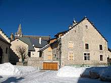
- A Romanesque church is located on a hill in the centre of the village. Only the bell tower is from the Middle Ages (12th to 13th centuries), its stone spire dates back to the 17th and 18th centuries, the choir and the nave of the building are from 1875.
Archaeological Heritage
Autrans has three sites: a Motte-and-bailey castle and two fortified houses at Malatan and La Tour hamlets. Of these three sites nothing remains except mounds and that can be seen today in the landscape.[10]
- The Motte du Chateau is located approximately 1 km to the east of Autrans Church on a Moraine. A wattle and daub building existed on the mound in the 11th century.
- Malatan is located approximately 300 m south-east of the Motte du Chateau and is an old fortified house probably dating from the 14th century.
- The Tower is located approximately 200 m to the north of the hamlet of Andrevières and excavations have identified the remains of a round tower probably dating from the 12th century.
Underground heritage
- The Ture Cave is located near the hamlet of Naves. It is used today for an introduction to caving or the simple discovery of an underground world because it has fairly easy access.[11]
Local life
Sports
The Gève Domain is located 1,300 m above sea level and has an international reputation. Located to the north of the Massif du Vercors, the snow conditions are exceptional. This area is accessible by car and there are free shuttles to all valid ski pass holders for the Autrans ski resort.[12]
Sporting events
- The Foulée blanche (White Stride) event has been held every year since 1979 in January, It is a cross-country ski race attracting nearly 5,000 participants.[13]
Cultural Events

- The Autrans Internet Meeting is an annual event dedicated to the understanding of the future of the Internet. The event started in 1997 and is held every year in January.
Education
The town has a public kindergarten and a public primary school.[14]
Notable people linked to the commune
- Léonce-Émile Durand-Savoyat, former mayor of Autrans, MP and Senator for Isère.
- Many natives of Autrans have been members of different French national ski teams and have won many national titles.
See also
Notes
- ↑ At the beginning of the 21st century, the methods of identification have been modified by Law No. 2002-276 of 27 February 2002, the so-called "law of local democracy" and in particular Title V "census operations" allows, after a transitional period running from 2004 to 2008, the annual publication of the legal population of the different French administrative districts. For communes with a population greater than 10,000 inhabitants, a sample survey is conducted annually, the entire territory of these communes is taken into account at the end of the period of five years. The first "legal population" after 1999 under this new law came into force on 1 January 2009 and was based on the census of 2006.
References
- ↑ Arrêté préfectoral 20 November 2015
- ↑ 1968 Winter Olympics official report. pp. 85-95. (English) & (French)
- ↑ Inhabitants of Isère (French)
- ↑ Autrans in the Competition for Towns and Villages in Bloom Archived December 10, 2014, at the Wayback Machine. (French)
- ↑ Google Maps
- ↑ Timetable for route 5120, on the Trans-Isere website (French)
- ↑ Géoportail, IGN (French)
- ↑ List of Mayors of France (French)
- ↑ National Commission for Decentralised cooperation (French)
- ↑ Isère heritage website for Autrans (French)
- ↑ PNV website on the Ture Cave (French)
- ↑ OT of Autrans skiing website Archived June 13, 2014, at the Wayback Machine.
- ↑ The Foulée blanche website Archived July 14, 2014, at the Wayback Machine. (French)
- ↑ Official Academy of Grenoble website (French).
External links
| Wikimedia Commons has media related to Autrans. |
- Autrans official website (French)
- Festitrail of Autrans (French)
- Autrans on Lion1906
- Autran on the 1750 Cassini Map
- Autrans on the INSEE website (French)
- INSEE (French)


