Atur, Dordogne
| Atur | |
|---|---|
 | |
 Atur | |
|
Location within Nouvelle-Aquitaine region 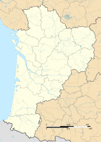 Atur | |
| Coordinates: 45°08′29″N 0°44′55″E / 45.1414°N 0.7486°ECoordinates: 45°08′29″N 0°44′55″E / 45.1414°N 0.7486°E | |
| Country | France |
| Region | Nouvelle-Aquitaine |
| Department | Dordogne |
| Arrondissement | Périgueux |
| Canton | Saint-Pierre-de-Chignac |
| Intercommunality | Isle Manoire en Périgord |
| Government | |
| • Mayor (2008–2014) | Alain Cournil |
| Area1 | 19.13 km2 (7.39 sq mi) |
| Population (2008)2 | 1,719 |
| • Density | 90/km2 (230/sq mi) |
| Time zone | CET (UTC+1) |
| • Summer (DST) | CEST (UTC+2) |
| INSEE/Postal code | 24013 / 24750 |
| Elevation | 115–271 m (377–889 ft) |
|
1 French Land Register data, which excludes lakes, ponds, glaciers > 1 km² (0.386 sq mi or 247 acres) and river estuaries. 2 Population without double counting: residents of multiple communes (e.g., students and military personnel) only counted once. | |
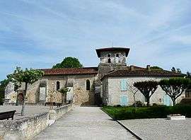
Atur (Occitan: Astur) is a former commune in the Dordogne department in southwestern France. On 1 January 2016, it was merged into the new commune Boulazac-Isle-Manoire.[1]
Population
| Historical population | ||
|---|---|---|
| Year | Pop. | ±% |
| 1793 | 770 | — |
| 1800 | 774 | +0.5% |
| 1806 | 790 | +2.1% |
| 1821 | 777 | −1.6% |
| 1831 | 832 | +7.1% |
| 1836 | 772 | −7.2% |
| 1841 | 750 | −2.8% |
| 1846 | 812 | +8.3% |
| 1851 | 840 | +3.4% |
| 1856 | 791 | −5.8% |
| 1861 | 807 | +2.0% |
| 1866 | 802 | −0.6% |
| 1872 | 774 | −3.5% |
| 1876 | 777 | +0.4% |
| 1881 | 820 | +5.5% |
| 1886 | 767 | −6.5% |
| 1891 | 740 | −3.5% |
| 1896 | 734 | −0.8% |
| 1901 | 710 | −3.3% |
| 1906 | 701 | −1.3% |
| 1911 | 684 | −2.4% |
| 1921 | 570 | −16.7% |
| 1926 | 571 | +0.2% |
| 1931 | 546 | −4.4% |
| 1936 | 555 | +1.6% |
| 1946 | 567 | +2.2% |
| 1954 | 516 | −9.0% |
| 1962 | 517 | +0.2% |
| 1968 | 560 | +8.3% |
| 1975 | 836 | +49.3% |
| 1982 | 1,082 | +29.4% |
| 1990 | 1,248 | +15.3% |
| 1999 | 1,490 | +19.4% |
| 2008 | 1,719 | +15.4% |
See also
References
- ↑ Arrêté préfectoral 14 December 2015 (French)
| Wikimedia Commons has media related to Atur. |
This article is issued from Wikipedia - version of the 7/21/2016. The text is available under the Creative Commons Attribution/Share Alike but additional terms may apply for the media files.