Arizona State Route 83
| ||||
|---|---|---|---|---|
 | ||||
| Route information | ||||
| Maintained by ADOT | ||||
| Length: | 53.63 mi[1] (86.31 km) | |||
| Existed: | 1927 – present | |||
| Major junctions | ||||
| South end: | Parker Canyon Lake | |||
| North end: |
| |||
| Highway system | ||||
| ||||
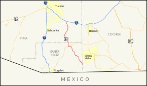
State Route 83 (SR 83) is a scenic state highway in southern Arizona, stretching from its junction with Interstate 10 near Vail south to Parker Canyon Lake. It passes through sparsely populated areas of Pima, Cochise and Santa Cruz Counties, passing through the wine towns of Sonoita and Elgin.
Route description
The southern terminus of Route 83 is located at Parker Canyon Lake. It heads northwest from the lake and passes through Sonoita before it reaches a junction with SR 82. It continues to the north from this junction to its northern terminus at an interchange with I-10 near Vail, southeast of Tucson. [1][2]
Junction list
| County | Location | mi[1] | km | Destinations | Notes |
|---|---|---|---|---|---|
| Cochise | | 0.00 | 0.00 | Parker Canyon Lake | |
| Santa Cruz | | 28.19 | 45.37 | ||
| Pima | | 53.63 | 86.31 | ||
| 1.000 mi = 1.609 km; 1.000 km = 0.621 mi | |||||
References
- 1 2 3 Arizona Department of Transportation. "2008 ADOT Highway Log" (PDF). Retrieved April 9, 2008.
- ↑ Google (2008-04-24). "overview map of SR 83" (Map). Google Maps. Google. Retrieved 2008-04-24.
External links
This article is issued from Wikipedia - version of the 11/8/2016. The text is available under the Creative Commons Attribution/Share Alike but additional terms may apply for the media files.
