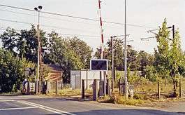
Ardleigh railway station
| Ardleigh | |
|---|---|
|
Location of the station (1991) | |
| Location | |
| Place | Ardleigh |
| Area | District of Tendring |
| Operations | |
| Original company | Eastern Union Railway |
| Pre-grouping | Great Eastern Railway |
| Post-grouping |
London and North Eastern Railway Eastern Region of British Railways |
| Platforms | 2 |
| History | |
| 15 June 1846 | Station opens |
| 6 November 1967 | Station closes |
| Disused railway stations in the United Kingdom | |
|
Closed railway stations in Britain A B C D–F G H–J K–L M–O P–R S T–V W–Z | |
|
| |
Ardleigh railway station served the village of Ardleigh in Essex, England. The station was situated on the Great Eastern Main Line.
History
Opened by the Eastern Union Railway, then absorbed by the Great Eastern Railway, it joined the London and North Eastern Railway during the Grouping of 1923. The line then passed on to the Eastern Region of British Railways on nationalisation in 1948.
There were sidings on both the down and up side at the London end of the station.[1] Those on the up side included goods sheds and handled both horticultural and seed traffics until the goods service was closed on 7 December 1964.[2]
The station was then closed for passenger traffic by the British Railways Board on 6 November 1967.[3]
The site today
Trains pass the site on the electrified Great Eastern Main Line.
| Preceding station | Historical railways | Following station | ||
|---|---|---|---|---|
| Manningtree Line Open, Station Open |
Eastern Region of British Railways Great Eastern Main Line |
Colchester Line Open, Station Open | ||
References
- ↑ Mitchell, Victor E. (April 2011). Eastern Main Lines - Shenfield to Ipswich. Midhurst: Middleton Press. Plan XI. ISBN 978 1 906008 96 3.
- ↑ Mitchell 2011, Plate 92
- ↑ Mitchell 2011, Plate 93
Further reading
- Butt, R. V. J. (1995). The Directory of Railway Stations: details every public and private passenger station, halt, platform and stopping place, past and present (1st ed.). Sparkford: Patrick Stephens Ltd. ISBN 1-8526-0508-1. OCLC 60251199.
- Jowett, Alan (2000). Jowett's Nationalised Railway Atlas (1st ed.). Penryn, Cornwall: Atlantic Transport Publishers. ISBN 0-9068-9999-0. OCLC 228266687.
External links
Coordinates: 51°55′17″N 0°59′04″E / 51.92136°N 0.98440°E
