Sankhaburi District
| Sankhaburi สรรคบุรี | |
|---|---|
| Amphoe | |
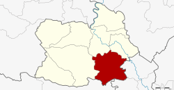
 Amphoe location in Chainat Province | |
| Coordinates: 15°2′50″N 100°9′42″E / 15.04722°N 100.16167°ECoordinates: 15°2′50″N 100°9′42″E / 15.04722°N 100.16167°E | |
| Country |
|
| Province | Chainat |
| Seat | Phraek Si Racha |
| Area | |
| • Total | 354.8 km2 (137.0 sq mi) |
| Population (2008) | |
| • Total | 67,333 |
| • Density | 192.8/km2 (499/sq mi) |
| Time zone | THA (UTC+7) |
| Postal code | 17140 |
| Geocode | 1805 |
Sankhaburi (Thai: สรรคบุรี) is a district (Amphoe) in the southern part of Chainat Province, central Thailand.
Geography
Neighboring districts are (from the west clockwise) Hankha, Mueang Chainat, Sapphaya of Chainat Province, In Buri, Bang Rachan of Sing Buri Province and Doem Bang Nang Buat of Suphanburi Province.
Administration
The district is subdivided into 8 subdistricts (tambon), which are further subdivided into 92 villages (muban). Phraek Si Racha is a township (thesaban tambon) which covers parts of tambon Phraek Si Racha. There are further 8 Tambon administrative organizations (TAO).
| No. | Name | Thai | Villages | Inh.[1] |
|---|---|---|---|---|
| 1. | Phraek Si Racha | แพรกศรีราชา | 16 | 16,467 |
| 2. | Thiang Thae | เที่ยงแท้ | 10 | 6,283 |
| 3. | Huai Krot | ห้วยกรด | 9 | 9,012 |
| 4. | Pho Ngam | โพงาม | 13 | 7,692 |
| 5. | Bang Khut | บางขุด | 12 | 7,316 |
| 6. | Dong Khon | ดงคอน | 16 | 12,121 |
| 7. | Don Kam | ดอนกำ | 8 | 2,926 |
| 8. | Huai Krot Phatthana | ห้วยกรดพัฒนา | 8 | 5,516 |
References
- ↑ "Population statistics 2008". Department of Provincial Administration.
External links
- amphoe.com (Thai)
This article is issued from Wikipedia - version of the 11/20/2016. The text is available under the Creative Commons Attribution/Share Alike but additional terms may apply for the media files.