Alfarnatejo
| Alfarnatejo | |
|---|---|
| Municipality and town | |
|
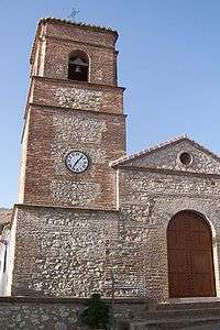
Alfarnatejo church | |
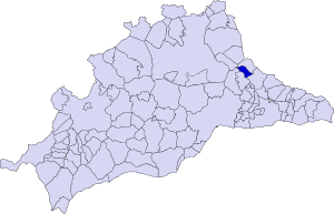
 Municipal location in Málaga Province | |
 Alfarnatejo Location in Spain | |
| Coordinates: 36°59′N 4°16′W / 36.983°N 4.267°W | |
| Country |
|
| Autonomous community | Andalucía |
| Province | Málaga Province |
| Comarca | Axarquía - Costa del Sol |
| Area | |
| • Total | 8 sq mi (20 km2) |
| Elevation | 2,946 ft (898 m) |
| Population (2008) | |
| • Total | 516 |
| • Density | 58/sq mi (22.4/km2) |
| Time zone | CET (UTC+1) |
| • Summer (DST) | CEST (UTC+2) |
| Website | http://www.alfarnatejo.es |
Alfarnatejo is a town and municipality in the province of Málaga, part of the autonomous community of Andalusia in southern Spain. The municipality is situated approximately 50 km from the city of Málaga. It has a population of approximately 400 residents. The natives are called Tejones and the town's neighbors in Alfarnate are Palancos.
It is located near the Sierra del Jobo in the northwest and the Sierra de Alhama in the east in the mountainous region of Axarquía.[1]
References
External links
| Wikimedia Commons has media related to Alfarnatejo. |
Coordinates: 37°00′N 4°16′W / 37.000°N 4.267°W
This article is issued from Wikipedia - version of the 9/16/2015. The text is available under the Creative Commons Attribution/Share Alike but additional terms may apply for the media files.
