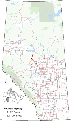
Alberta Highway 33

Alberta Highway 33 shield Grizzly Highway shield

Highway 33
Grizzly Trail
Route information
Length: 236 km (147 mi)
Major junctions
South end: Hwy 43 near Gunn
  Hwy 18
Hwy 32
North end: Hwy 2 near Kinuso
Location
Specialized
and rural
municipalities:
Lac Ste. Anne County, Barrhead No. 11 County, Woodlands County, Big Lakes County
Towns: Barrhead, Swan Hills
Highway system

Provincial highways in Alberta

Hwy 32Hwy 35

Alberta Provincial Highway No. 33,[1] also named Grizzly Trail, is a north–south highway located in west–central Alberta, Canada.

From the north, Highway 33 begins at its intersection with Highway 2, approximately 5.0 km (3.1 mi) east of the Hamlet of Kinuso and proceeds south through Swan Hills and Barrhead to Highway 43 near Gunn.

Major intersections

From south to north:

MunicipalitykmDescription Location
Lac Ste. Anne County 0 Begins at Hwy 43 near Gunn 53°43′55″N 114°20′11″W / 53.73190°N 114.33643°W / 53.73190; -114.33643 (33 x 43)
14 Passes through the Hamlet of Rich Valley 53°51′06″N 114°21′04″W / 53.85155°N 114.35120°W / 53.85155; -114.35120 (33 x Rich Valley)
25 Passes through the Summer Village of Birch Cove on Lac La Nonne 53°57′20″N 114°22′25″W / 53.95557°N 114.37374°W / 53.95557; -114.37374 (33 x Birch Cove)
County of Barrhead No. 11 28 Intersects with Hwy 651 eastbound 53°58′39″N 114°22′25″W / 53.97759°N 114.37373°W / 53.97759; -114.37373 (33 x 651)
30 Crosses the Pembina River 53°59′36″N 114°23′00″W / 53.99329°N 114.38339°W / 53.99329; -114.38339 (33 x Pembina River)
32 Intersects with Hwy 654 westbound
Highway 654 concurrency begins
54°00′24″N 114°23′57″W / 54.00677°N 114.39918°W / 54.00677; -114.39918 (33 x 654W)
38 Intersects with Hwy 654 eastbound
Highway 654 concurrency ends
54°03′54″N 114°24′01″W / 54.06488°N 114.40016°W / 54.06488; -114.40016 (33 x 654E)
Town of Barrhead 43 Enters the Town of Barrhead 54°06′27″N 114°24′07″W / 54.10756°N 114.40181°W / 54.10756; -114.40181 (33 x Barrhead)
45 Intersects Hwy 18 westbound at Barrhead
Highway 18 concurrency begins
54°07′23″N 114°24′07″W / 54.12312°N 114.40184°W / 54.12312; -114.40184 (33 x18W)
County of Barrhead No. 11 48 Intersects Hwy 18 eastbound near Barrhead
Highway 18 concurrency ends
54°09′08″N 114°24′06″W / 54.15221°N 114.40179°W / 54.15221; -114.40179 (33 x 18E)
67 Passes through Camp Creek 54°14′59″N 114°35′00″W / 54.24980°N 114.58328°W / 54.24980; -114.58328 (33 x Camp Creek)
80 Intersects with Hwy 763 southbound 54°18′28″N 114°45′06″W / 54.30769°N 114.75173°W / 54.30769; -114.75173 (33 x 763)
Woodlands County 82 Crosses the Athabasca River 54°19′14″N 114°47′05″W / 54.32058°N 114.78466°W / 54.32058; -114.78466 (33 x Athabasca River)
84 Intersects with Hwy 661 northbound near Fort Assiniboine 54°20′02″N 114°47′21″W / 54.33392°N 114.78923°W / 54.33392; -114.78923 (33 x 661)
91 Intersects with Hwy 658 westbound 54°22′04″N 114°52′36″W / 54.36773°N 114.87657°W / 54.36773; -114.87657 (33 x 658)
Town of Swan Hills 142 Enters the Town of Swan Hills 54°42′36″N 115°21′51″W / 54.71005°N 115.36424°W / 54.71005; -115.36424 (33 x Swan Hills)
145 Intersects with Hwy 32 southbound at Swan Hills 54°42′38″N 115°24′48″W / 54.71054°N 115.41344°W / 54.71054; -115.41344 (33 x 32)
Big Lakes County 219 Intersects with Hwy 2 near Kinuso, south of the Lesser Slave Lake 55°18′58″N 115°21′37″W / 55.31612°N 115.36039°W / 55.31612; -115.36039 (33 x 2)
1.000 mi = 1.609 km; 1.000 km = 0.621 mi

References

  1. Provincial Highways Designation Order, Alberta Transportation, p. 6

External links

This article is issued from Wikipedia - version of the 10/25/2016. The text is available under the Creative Commons Attribution/Share Alike but additional terms may apply for the media files.