Akiachak Airport
| Akiachak Airport | |||||||||||
|---|---|---|---|---|---|---|---|---|---|---|---|
 | |||||||||||
| IATA: KKI – ICAO: none – FAA LID: Z13 | |||||||||||
| Summary | |||||||||||
| Airport type | Public | ||||||||||
| Owner | State of Alaska DOT&PF | ||||||||||
| Serves | Akiachak, Alaska | ||||||||||
| Elevation AMSL | 25 ft / 8 m | ||||||||||
| Coordinates | 60°54′22″N 161°25′37″W / 60.90611°N 161.42694°W | ||||||||||
| Runways | |||||||||||
| |||||||||||
| Statistics | |||||||||||
| |||||||||||
Akiachak Airport (IATA: KKI, FAA LID: Z13) is a state-owned public-use airport located in Akiachak, in the Bethel Census Area of the U.S. state of Alaska.[1]
As per Federal Aviation Administration records, this airport had 2,607 passenger boardings (enplanements) in calendar year 2007, an increase of 44% from the 1,811 enplanements in 2006.[2]
Facilities
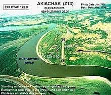
Akiachak Airport has one runway designated 11/29 with a 1,649 by 40 ft (503 x 12 m) gravel surface. For the 12-month period ending August 26, 2005, the airport had 3,000 aircraft operations, an average of 250 per month, all of which were air taxi.[1]
The state has plans to acquire 236 acres (0.96 km2) to relocate the airport and build a new 3,300-foot (1,000 m) runway.[3][4]
Airlines and destinations
| Airlines | Destinations |
|---|---|
| Yute Air | Akiak, Bethel, Kwethluk, Tuluksak |
References
- 1 2 3 FAA Airport Master Record for Z13 (Form 5010 PDF), effective 2008-07-31.
- 1 2 Preliminary CY 2007 Passenger Boarding and All-Cargo Data. Federal Aviation Administration. 2008-07-17.
- ↑ Akiachak Airport Relocation. Online Public Notice. State of Alaska. 2007-10-30.
- ↑ Akiachak Airport Relocation (PDF). State of Alaska Capital Project Summary. Department of Transportation and Public Facilities. 2007-12-10.
External links
- Airport diagram from FAA, Alaskan Region (GIF)
- Resources for this airport:
- FAA airport information for Z13
- AirNav airport information for Z13
- FlightAware airport information and live flight tracker
- SkyVector aeronautical chart for Z13
This article is issued from Wikipedia - version of the 10/3/2015. The text is available under the Creative Commons Attribution/Share Alike but additional terms may apply for the media files.